Why Certified Surveyors Are Still Essential in the Age of Drone Surveying
Why Human Expertise Still Matters in the Age of Drone Services and Automation
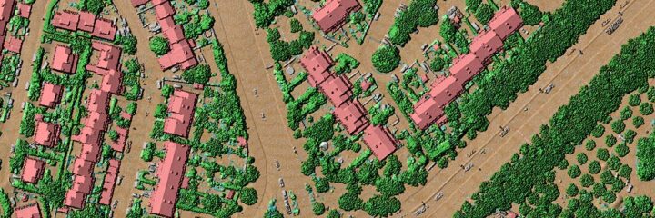
As technology continues to evolve, drone services, LiDAR, and automated data processing are rapidly transforming the way we approach modern surveying. What used to take weeks with chains, total stations, and field crews can now be completed in hours using aerial drone services. Drone services have unlocked new possibilities for construction, infrastructure, agriculture, energy, and land development industries by making data collection faster, safer, and more accessible.
But with this shift comes a crucial question: Do we still need certified surveyors when drones can do the job?
The answer is a clear and resounding YES. Despite the rise of reality data capture and automation, licensed surveyors continue to play an indispensable role in ensuring that the data collected is accurate, meaningful, legally valid, and safely applied in the real world.
Let’s explore how licensed surveyors continue to add value in a drone-driven industry and why the fusion of human expertise and technology is essential for the future of surveying.
How Drone Services Are Transforming Surveying
Over the past decade, drone services have revolutionized the field of surveying. What once required large survey crews and complex logistics can now be executed by a trained drone pilot with the right payloads and software. Tools now common in modern surveying include:
- Drones (UAVs) equipped with high-resolution cameras or LiDAR sensors
- Photogrammetry software that transforms 2D images into 3D models and maps
- RTK and PPK GPS systems for centimeter-level accuracy in drone positioning
- Cloud platforms that allow teams to collaborate and access data remotely
These aerial drone services make it possible to survey construction sites, agriculture fields, mining operations, and utility corridors with incredible speed. The ability to capture thousands of data points in a single flight has changed the game. What used to be physically demanding and time-consuming is now efficient and scalable.
But raw speed and data density are not enough on their own. Surveying is not just about capturing the surface of the earth. It’s about interpreting it, validating it, and applying it correctly.
The Critical Role of Licensed Surveyors
Licensed surveyors are not just technicians. They are certified professionals with deep expertise in land law, geometry, measurement, and public safety. Their role is much broader and more complex than simply capturing data. Here’s why they remain vital in today’s technology-driven industry:
1. Legal Authority and Compliance
One of the most fundamental aspects of land surveying is that it’s a regulated profession. Certified surveyors are licensed by state boards and are the only individuals authorized to legally establish property boundaries, resolve land disputes, or sign off on subdivision plats, easements, and construction surveys.
Aerial drone services may collect imagery or elevation data, but that data does not hold legal weight unless it has been verified and certified by a licensed surveyor. For applications involving deeds, permitting, insurance, zoning, or construction, only a licensed surveyor’s stamp is recognized by law.
2. Accuracy and Quality Control
Drones may be excellent tools for capturing large volumes of data, but more data doesn’t automatically mean better data. There are dozens of ways that inaccuracies can sneak into a survey, such as improperly placed ground control points, sensor miscalibration, GPS drift, or post-processing errors.
Licensed surveyors understand geodetic principles, coordinate systems, datums, and tolerances. They are trained to cross-check aerial data with ground measurements, verify outputs, and ensure that deliverables meet project-specific standards. Without that professional oversight, the risk of costly errors grows substantially.
3. Interpretation and Real-World Judgment
Surveying is not just a science; it’s also an art. Understanding how the landscape interacts with infrastructure, how zoning ordinances impact boundary layouts, or how hydrology affects terrain is beyond what drones can comprehend.
Surveyors apply professional judgment in complex conditions. For example, they might be called on to interpret overlapping deed descriptions, make determinations in areas with no clear historical boundaries, or assess terrain for engineering feasibility. These are not tasks that aerial drone services or software can accomplish alone.
4. Accountability and Ethics
Licensed surveyors operate under a strict code of ethics and are liable for the work they produce. They carry professional insurance and are subject to disciplinary action by their licensing boards. This level of accountability ensures that the work is performed with integrity and that public safety is prioritized.
In contrast, drone services operated by non-surveyors may produce data without the same level of responsibility. This creates a risk if the data is used for decision-making in construction, development, or land transfer without the appropriate legal review.

The Power of Collaboration: Tech + Surveyor Expertise
Rather than replacing certified professionals, drone services and aerial drone services empower surveyors to do their work better and faster. In fact, the best outcomes often come from a hybrid approach, combining field experience with technology.
Examples of effective collaboration include:
- Surveyors leading drone missions to ensure proper setup, flight planning, and data integrity
- Combining traditional total station surveys with drone-captured photogrammetry for high-precision overlays
- Using drone imagery to provide visual documentation for ALTA surveys or construction site assessments
- Post-processing drone data under the supervision of a licensed surveyor, ensuring that maps and models meet regulatory standards
This partnership not only improves workflow efficiency but also ensures that deliverables are defensible, compliant, and accurate.

The Evolving Role of the Surveyor in a Tech-Driven Industry
As drone technology and reality data capture platforms continue to evolve, so too does the role of the modern surveyor. Today’s professionals are blending traditional skills with digital literacy to stay ahead of the curve.
Modern surveyors now need to:
- Understand drone flight planning and FAA regulations
- Be proficient with GIS platforms and cloud-based mapping tools
- Work with 3D point clouds and digital twins
- Oversee post-processing software and accuracy checks
- Interpret massive datasets generated by aerial drone services
Those who embrace this change are leading the way in smart cities, renewable energy, disaster recovery, environmental conservation, and more. They are not just measuring the earth, they’re managing and protecting it using the latest tools.

Why Surveyors Still Matter
The world of surveying is changing fast, but one thing remains constant: the need for expertise, judgment, and legal authority. Drone services and aerial drone services are invaluable tools, but they do not eliminate the responsibilities held by licensed surveyors.
When drone data is collected without proper oversight, the results can be flawed, misleading, or legally invalid. When collected in partnership with a licensed surveyor, the data becomes meaningful, accurate, and trustworthy.
Surveying is no longer just about measuring distance, it’s about building bridges between data and decisions, between maps and the real world.
Automation captures the reality. But licensed surveyors define and validate it.