
Understanding Digital Surface Models, Digital Terrain Models, and Digital Elevation Models
Elevation data is critical for a wide range of applications in various fields. It plays a key role in helping us better understand and manage the Earth’s resources and environment. This data is collected through various techniques, typically aerial data capture and LiDAR sensors.
Common Uses of Elevation Data
Mapping & Surveying
Elevation data creates accurate maps and topographic surveys of the Earth’s surface. This information is essential for urban planning, forestry, and natural resource management.
Infrastructure Planning and Design
Elevation data is crucial for planning and designing projects such as roads, bridges, and buildings. It helps determine the optimal route, slope, and elevation of these projects, ensuring they are safe and structurally sound.
Hydrology
Elevation data models water flow and drainage, which is critical for predicting flood risks, managing water resources, and protecting natural habitats.
Environmental Monitoring
Elevation data monitors changes in the Earth’s surface over time, including erosion, land use changes, and deforestation. This information helps scientists understand the impact of human activities on the environment and develop strategies for mitigating negative effects.
Disaster Response
Elevation data assesses the damage caused by natural disasters, helping emergency responders plan relief efforts and allocate resources more effectively.
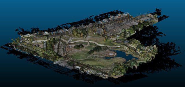
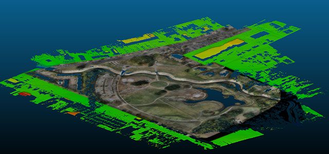
Once collected, elevation data is processed and analyzed using software tools that generate 3D models and visualizations of the Earth’s surface. The two primary types of elevation models are Digital Surface Model (DSM) and Digital Terrain Model (DTM). Each model represents the elevation data differently, depending on how the data needs to be applied.
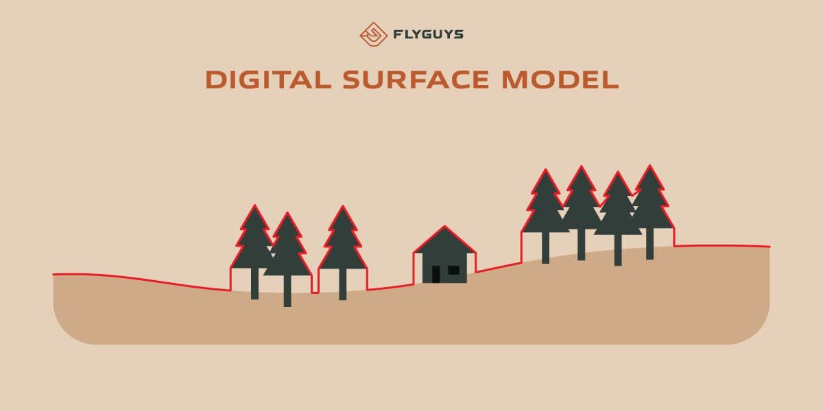
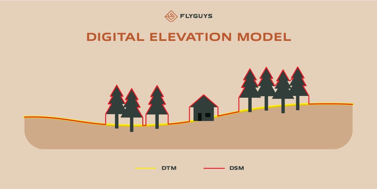
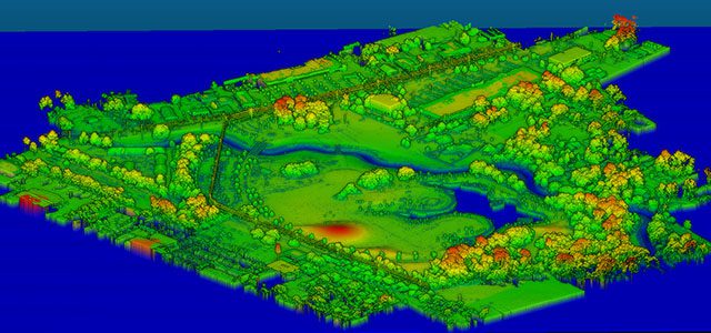
Digital Surface Models (DSMs)
Digital Surface Models represent the topography of the Earth’s surface, including all objects on it, such as trees, buildings, and other features. DSMs are created using aerial data capture methods like LiDAR (Light Detection and Ranging) or photogrammetry. LiDAR uses laser beams to measure the distance between the sensor and the ground, while photogrammetry uses aerial photographs to create 3D models.
Benefits of DSMs
- Accuracy: DSMs accurately represent the Earth’s surface, allowing users to measure features precisely and make informed decisions.
- 3D Visualization: DSMs provide realistic and immersive 3D visualizations of the Earth’s surface, beneficial for urban planning and design.
- High-Resolution Data: DSMs capture high-resolution data, offering detailed and accurate elevation measurements essential for industries modeling water flow and drainage.
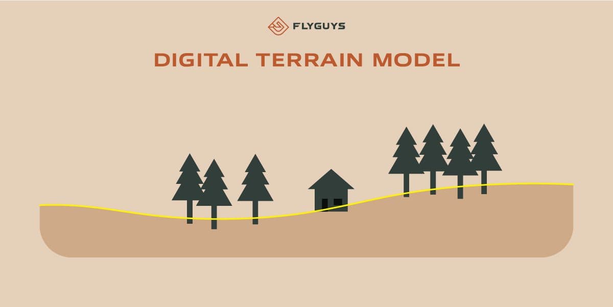
Digital Terrain Models (DTMs)
Digital Terrain Models represent the bare earth surface without any features such as buildings or vegetation. DTMs are created using methods similar to DSMs, such as LiDAR or photogrammetry, but require additional processing to remove objects above the ground, known as “bare-earth extraction.”
Components of a DTM
- Surface: Represents the bare earth.
- Elevation: The elevation at each point on the surface.
- Slope: The slope at each point on the surface.
Benefits of DTMs
- Terrain Analysis: DTMs are useful for slope and aspect calculations, hydrological modeling, and geological applications.
- Contour Line Creation: DTMs can create contour lines, helping in building roads or railroad tracks by identifying obstacles like trees or rocks before construction begins.
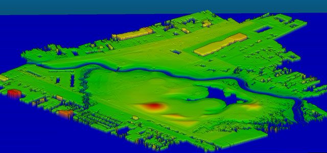
Digital Elevation Models (DEMs)
Digital Elevation Models represent the elevation of the Earth’s surface and can be either a DSM or DTM. DEMs are a 3D grid of terrain elevations collected from an area with satellite imagery or LiDAR technology.
Uses of DEMs
- Landscape Visualization: DEMs are useful for visualizing landscape changes over time.
- Natural Phenomena Simulations: They create simulations of natural phenomena like landslides and floods.
- Land Use Changes: DEMs help measure land use changes over time and can be combined with other models for more detailed representations of the Earth’s surface.
Benefits of Digital Models
Digital models offer numerous benefits over traditional methods of mapping and surveying:
- Accuracy: They accurately represent the Earth’s surface, allowing for better decision-making and planning.
- Efficiency: Digital models can be created quickly and efficiently using aerial data capture methods such as LiDAR, reducing the need for ground-based surveys and minimizing environmental impact.
- Versatility: Digital models can be easily shared and used in many applications, making them a valuable resource for various industries. They can be used in GIS software for spatial analysis, integrated into 3D modeling software, or applied in conjunction with other data sources like satellite imagery.
Aerial Data Capture and LiDAR
Aerial data capture methods such as LiDAR have revolutionized how we map and analyze the Earth’s surface. LiDAR emits laser beams from a sensor mounted on an aircraft, which bounce off the Earth’s surface and return to the sensor. The time it takes for the laser beam to return to the sensor is used to calculate the distance between the sensor and the ground.
LiDAR can collect data over large areas quickly and efficiently, making it ideal for creating digital models of the Earth’s surface. It is particularly useful in areas with complex topography where ground-based surveys would be difficult or impossible.
The Simple Breakdown
DSM (Digital Surface Model)
- Includes: All objects on the Earth’s surface such as trees, buildings, and other features.
- Uses: Land-use planning, urban modeling, and forestry.
DTM (Digital Terrain Model)
- Includes: Bare earth surface elevation with all features removed, including buildings, trees, and other objects.
- Uses: Terrain analysis, slope and aspect calculations, hydrological modeling, and geological applications.
DEM (Digital Elevation Model)
- Includes: Earth’s elevation, either as a DSM or DTM.
- Uses: Urban planning, forestry, land-use planning, and provides a comprehensive understanding of topography.
As technology advances, digital models will become more prevalent and valuable in many areas. By understanding the differences between these models and their benefits, we can continue to make informed decisions and utilize these powerful tools to their fullest potential, enhancing our understanding of the world around us.