Overcoming Apprehension: How LiDAR Can Benefit Your Surveying Needs, an Interview with FlyGuys’ Sales Rep

“Hi there! My name is Jessica, and I specialize in providing LiDAR services to companies like yours.” This is a daily introduction that can be heard through the walls of the FlyGuys’ headquarters, muffled but still easy to hear. Selling LiDAR services to potential clients can be a challenging task as it involves educating clients about the technology, proving its validity, and addressing concerns – of which there are plenty.
We spoke with FlyGuys’ National Account Manager, Jessica Slaughter about her approach to selling LiDAR services. “I am selling a service that will solve many problems clients face,” Jessica assures us.
Getting to know the client
Jessica understands that getting to know her customers is essential to providing the most effective LiDAR services. When approaching potential clients, she first consults on their needs and asks about their current LiDAR technology usage. It always intrigues her to know whether they currently use drones. By doing so, she can understand the clients’ perspective on LiDAR and tailor her conversation accordingly.
Jessica approaches her sales process as a problem-solver. Instead of just selling LiDAR services, Jessica works with her potential clients to identify their needs and understand how LiDAR can provide a solution. She learns about her clients’ current methods and any issues they face, such as inaccuracies or delays in data collection. By understanding their pain points, she can recommend a solution that utilizes LiDAR technology to provide accurate and efficient data collection.
“Once I get a feel for their problems and perception of the technology, it is easier to explain how I can leverage drone and LiDAR technology to streamline their operations, reduce labor costs and stay ahead of the curve.”
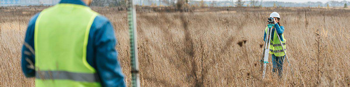
Survey Industry Challenges
Surveyors face many challenges daily, including labor strain. Surveying is a physically demanding job that involves working outdoors, often in harsh weather conditions, and walking and standing for extended periods. “Surveyors typically work long hours to meet project deadlines and are under pressure to produce accurate results,” Jessica explains. “This can lead to physical strain and burnout, resulting in reduced productivity, increased errors, and high turnover rates. There is also a shortage of skilled workers in the surveying industry, which further exacerbates the strain on the labor force.”
Another challenge surveyors face is technology evolution. If a survey company fails to keep up with evolving technology, they risk falling behind competitors and losing market share. Without technology adoption, survey companies struggle to attract clients seeking fast and accurate surveying services. Clients may seek more technologically advanced surveying services, leading to business loss. Additionally, outdated technology may result in inaccurate or incomplete survey data, which may lead to costly errors and delays in construction or development projects. Without LiDAR, surveyors must rely on traditional surveying methods that are slower, more labor-intensive, and less precise. This increases labor costs, longer project timelines, and potentially inaccurate data.
The Solution: LiDAR
“LiDAR technology provides a comprehensive solution to surveyor challenges,” Jessica concludes. “With LiDAR, surveyors can collect data remotely, allowing them to complete projects faster and more efficiently. This reduces the need for large teams and manual labor, easing the strain on the labor force. Additionally, accuracy and speed enable surveyors to deliver more precise results, which improve project outcomes and reduce errors. By adopting LiDAR technology, surveyors can improve productivity, save time, and lower costs.”
Moreover, LiDAR can help survey companies remain competitive in the rapidly evolving technology landscape. Jessica continues, “As more companies adopt the latest technology, those who fail to keep up risk falling behind and losing business. LiDAR offers surveyors a way to remain at the forefront of the industry, giving them a competitive edge over those who rely on outdated methods.” By embracing LiDAR, survey companies can keep up with their clients’ changing needs and maintain their position as industry leaders.
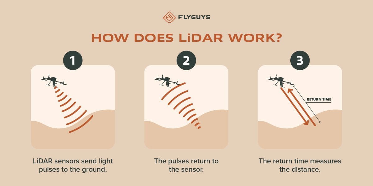
So, how does LiDAR work?
“Most of the time, potential clients know LiDAR capabilities,” Jessica explains. “But people often call to learn more about the technology because they realize they need to utilize it.” But no matter the level of understanding, Jessica educates all her clients on LiDAR’s potential and how it is used.
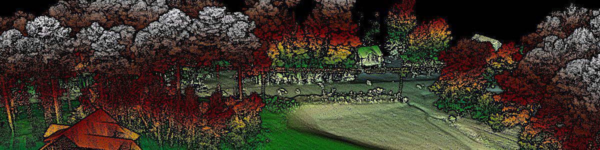
LiDAR is a remote sensing technology that measures distance by emitting a laser beam. It calculates the time light reflects off an object and returns to the sensor. LiDAR can be used for various applications, including mapping, surveying, and inspection. “For example, it can create highly accurate 3D models of terrain and structures, detect environmental changes, and even identify objects’ location and movement.”
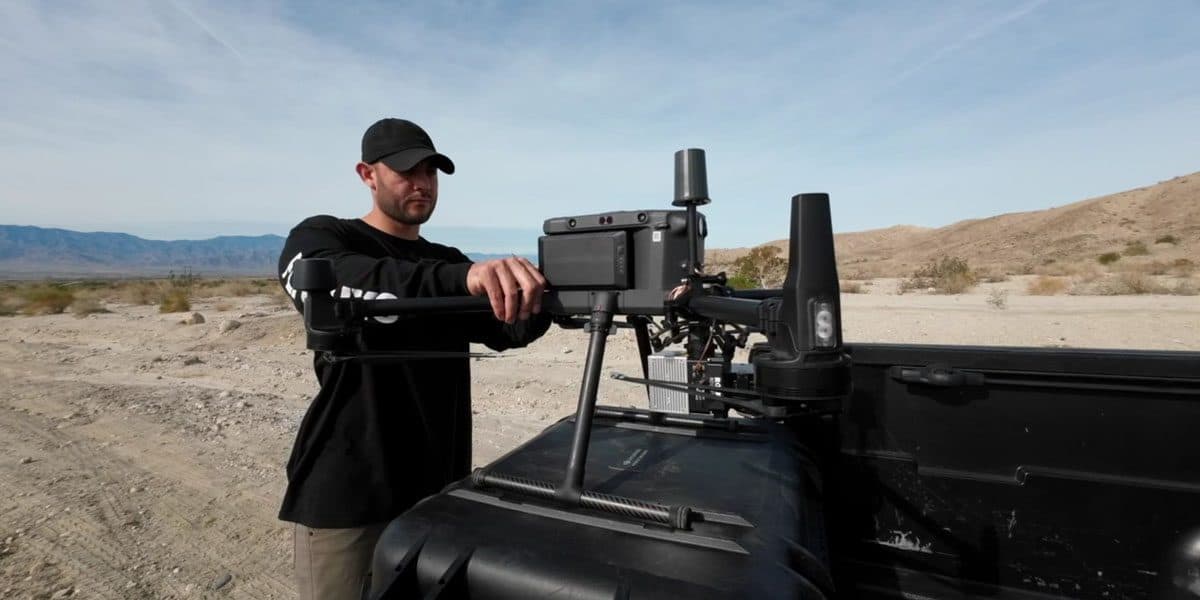
Jessica also explains that LiDAR technology is used with drones to capture data from above. “This allows for a more comprehensive and efficient data collection process. By using drones, surveyors can cover larger areas of land in less time.” Additionally, LiDAR data can be incorporated into the software to create highly detailed and accurate maps, reducing the likelihood of errors and improving the overall quality of the survey.
LiDAR objections
Some clients may oppose LiDAR due to its perceived expense and difficulty. In response, Jessica explains that LiDAR costs are generally lower than traditional surveying methods in the long term. Additionally, she emphasizes that LiDAR technology has become more user-friendly over the years, with streamlined processes and software that makes it easier to operate.
Other clients have concerns about LiDAR data accuracy, particularly in complex or irregular terrain. To address this, Jessica explains that LiDAR technology has advanced significantly in recent years, with improved accuracy and precision. She also highlights LiDAR’s ability to capture data from multiple angles, resulting in a more comprehensive understanding of the survey area.
“I often compare the adoption of LiDAR technology to the initial skepticism surrounding GPS technology in the late 1990s.” At that time, GPS was an emerging and relatively untested technology, and many surveyors were hesitant to embrace it, preferring traditional methods. However, as GPS technology matured and became more accurate, reliable, and cost-effective, surveyors realized its many benefits and quickly adopted it as a standard tool. “I tell clients that while LiDAR may be unfamiliar and even intimidating, as the technology continues to evolve and mature, it is becoming increasingly clear that it offers numerous advantages over traditional surveying methods, including increased speed, accuracy, and cost-effectiveness.” Jessica emphasizes to her clients that embracing new technology is essential to remaining competitive in the modern business landscape, just as it was with GPS back in 1999.
“Ultimately, my goal is to educate my clients on the benefits of LiDAR and to address any concerns they have in order to ensure they are making an informed decision about using the technology. And there really isn’t a better way to do this than getting the drone in the air and doing a side-by-side comparison of a traditional method versus a drone. Once they see this, their job is forever changed.”
The cost of LiDAR
LiDAR services can cost differently based on several factors,” Jessica states. “The cost starts around $6500, which is an all-inclusive rate for mobilization, LiDAR collection, and post-processing. We can collect 500 acres a day and process our standard deliverables and return them to the client 48-72 hours after collection is completed.”
- Size of the survey area. Larger areas require more equipment and time to complete, leading to higher costs.
- Type of terrain and vegetation. More rugged terrain or dense vegetation may require additional equipment or processing time, leading to higher costs.
- Level of accuracy required. Higher accuracy requirements may require more advanced equipment or longer processing times, leading to higher costs.
Despite the potential for higher costs, it’s imperative to consider the benefits of LiDAR. LiDAR can offer a significant increase in efficiency and accuracy compared to traditional surveying methods. This can lead to cost savings in the long run by reducing manual labor, decreasing errors, and providing more precise data. Additionally, LiDAR can allow surveyors to capture more data than previously possible, which can provide additional insights and value to clients.
“After weighing the benefits of LiDAR and the potential long-term costs of not using LiDAR, most clients have that aha moment,” Jessica notes.
LiDAR deliverables
Standard deliverables include:
- 2 .las point clouds
- 1 classified all points
- 1 classified ground points
Additional deliverables or services offered:
- 1ft. Contours (.dwg)
- Surface files (DTM)
“We can also give clients classifications such as man-made structures, low vegetation, or buildings and roads. Point clouds can also be colorized or uncolored, and we can fly Orthomosaic separately and tie into the same ground control, improving cover accuracy when surveyors utilize data sets for As-Builts.”
Case Study: LiDAR in action
To explain the benefits further, Jessica tells us about a recent mission flown for a civil engineering client. “We worked with MML&H in north Louisiana. We provided them with an exceptional topographical map using aerial LiDAR and photogrammetry. The heavily vegetated areas on the site would otherwise have required days of fieldwork and line cutting. This would have resulted in weeks of collection with fewer points than LiDAR. However, with our advanced technology, we collected millions of points in just one day, providing significantly higher accuracy and density than traditional surveying methods.
“Our team filled in any missing data with boundaries, inverts, and other critical information. We even tied our points to actual locations using structures on the site, resulting in a comprehensive survey. This not only saved MML&H valuable time and money but also provided them with a much more detailed and accurate topographical map than they would have received otherwise.”
The future of LiDAR
As a sales representative for LiDAR, Jessica has a keen eye for the future of LiDAR technology. She believes that the technology will continue to evolve and improve over time, with more sophisticated sensors and software being developed to increase accuracy and efficiency. She sees LiDAR becoming more prevalent in industries beyond surveying, such as autonomous vehicles and robotics.
“I anticipate that LiDAR will become more accessible and affordable for smaller companies, enabling them to compete more effectively with larger firms. I believe that LiDAR will become an essential tool for companies that want to remain competitive in their respective fields. With LiDAR’s ability to provide highly accurate and detailed data in a short amount of time, there is definitely a future where more companies will rely on LiDAR to make informed decisions and solve complex problems.” Overall, Jessica is excited about the potential of LiDAR and looks forward to seeing how the technology will continue to develop and be applied in the future.

Let’s schedule your LiDAR mission!
LiDAR technology has become a game-changer for the survey industry, and companies must incorporate it into their workflows to remain competitive. LiDAR service experts like Jessica help solve the challenges that surveyors face daily. These challenges include the strain on the labor force and keeping up with technology evolution. Through her approach to understanding her clients’ needs and educating them on LiDAR benefits, Jessica helps them achieve increased efficiency, accuracy, and cost savings. Although there may still be apprehension about the cost or complexity of the technology, it’s clear to see the benefits far outweigh any potential downsides. Looking to the future, LiDAR will be a vital and necessary tool for the survey industry. It will continue to evolve and innovate, which will enable surveyors to overcome new challenges and remain at the forefront of their field.
Discover more with LiDAR. Contact Jessica today to schedule a LiDAR consultation.