How Much do Drone LiDAR Services Cost?
Understanding Potential Costs
The first commercial uses of drones were centered on aerial video. Getting a bird’s eye view of a subject opened a new world to film makers, marketers, inspectors, and other professionals. In the time since those early flights, new technologies have turned drones into some of the most capable remote sensing platforms available.
Pricing Guide
Professionals are increasingly turning to LiDAR drone services to obtain better, more detailed data. As with any new technology, prospective buyers seek to better understand potential costs and the factors that affect those costs. FlyGuys has prepared this guide to shed some light into the cost of LiDAR services.
How LiDAR Works
Some projects require more data points and accuracy than traditional photogrammetry can offer. Light Detection and Ranging (LiDAR) provides more direct and accurate data while saving significant time and money.
LiDAR measures the distance from an emitter to the surface of the Earth. Light pulses from a laser and onboard sensors measure the time it takes the light to reflect off the surface and return to the unit. This data is turned into 3-D point clouds that can be used to create a variety of deliverables that are often used in industries such as construction, agriculture, civil engineering, surveying and many more.
Aerial UAV LiDAR systems can generally cover up to 500 acres a day in good conditions.
Pulses from the LiDAR unit are recorded and electronically compiled with GPS data and data from the inertial measurement unit (IMU) to create a digital representation of the scanned area in a point file format. Surveyors, Engineers and other professionals can use this data to build accurate deliverables for their clients.
Factors that Drive LiDAR Services Cost
There are various dimensions of service that drive the cost of LiDAR drone services. LiDAR services generally range from $6,500 to $9,000 per day and up to $12,000 depending on client needs. Discounts for high volume usage and multiple day usage can materially lower these costs.
Standard deliverables
As part of our LiDAR service, your guaranteed standard deliverables include two .las files. One file contains all points, and the second file contains only classified ground points. These files can be used to create topographical maps and other data products.
Sensors
FlyGuys currently utilizes three types of sensors. The sensor chosen for a given project will depend on the job requirements.
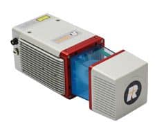
LiDARUSA Riegl MiniVUX
Our premier LiDAR sensor. Specifications include relative accuracy of up to 15 millimeters and precision of 10 millimeters, 200 kHz pulse repetition rate and a scan speed of up to 100,000 scans per second.
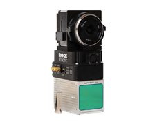
ROCK Robotic R2A
This sensor offers 240,000 points per second with accuracies of three to five centimeters.
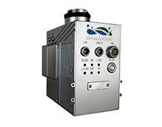
Green Valley LiAir V70
Our lowest cost sensor has a flexible scanner with specifications that include relative accuracy of 10 centimeters and 240,000 points per second for first return. Typically used by licensed professionals who don’t need the same degree of data collection precision and accuracy.
Terrain
The terrain of your project location may affect the cost of our LiDAR services for a variety of reasons.
Ease of Access
Some areas are harder to reach than others, and the pilot’s travel time to the site is a cost driver. Travel time and complexity of navigation are site factors we account for.
Makeup of Terrain
Mountainous areas, wetlands, and other natural obstacles all affect how line of sight and launch points are determined. Some sites are easy to fly while others require our pilots to launch from multiple points to maintain line of sight. In general a more complicated area to be flown means a more complicated LiDAR drone service job and higher cost.
Download LiDAR Report
Learn about LiDAR in this free download. Discover complete information on:
- How LiDAR works and what it’s used for
- How LiDAR helps further business objectives
- What sets FlyGuys’ LiDAR service apart

Different File Types That Drive LiDAR Service Cost
Sometimes a project requires more specific file types to be produced from the point cloud data. The following are additional items that can be produced from the datasets. Whether you produce these file types internally or externally they can add to the LiDAR service cost.
.DWG files
Two- and three- dimensional Auto CAD compatible files containing vector image data and metadata can generally be subsampled from .las for ease of use.
Contour Lines
Contours are available to show the difference in the land elevation. Minor and major lines from one to five foot contours are available with drone LiDAR services.
Classifications
If your project requires feature extractions, LiDAR datasets can remove high, medium and low vegetation as well as buildings, utilities and power lines. Classifying these features allows you to gain deeper insight into natural and man-made features of the terrain.
DEM, DTM, and DSM
Digital Elevation Models, Digital Terrain Models, and Digital Surface Models deliver an accurate representation of the elevation of the true ground.
- DEM – Represents the true ground absent of features like buildings and trees
- DSM – Includes both natural and man-made features of the environment surface
- DTM – Enhanced version of a DEM which includes vector data of natural features like rivers
3D Mesh
A 3D shape consisting of polygons and reference points. 3D meshes grant users an accurate spatial representation of a subject, enabling volume, area, and distance measurements.
Forestry Data
If the location of your project is in a wooded area, a LiDAR drone can accurately measure tree height, crown cover, volume, biomass and density of the forest. LiDAR can reach the ground surface through small openings in the canopy and foliage to capture depth data that is difficult to collect by traditional methods.
Let Us Help Spec Your LiDAR Drone Project
FlyGuys team of expert pilots and data specialists are available to consult and recommend the data types that will provide the greatest business impact for our clients.
If your next project requires more than standard photogrammetry or could benefit from more precise and accurate data collection, you need LiDAR drone services. Call FlyGuys today for a free quote at 1 (888) 837-0940 or email info@flyguys.com.
Get A Quote
Take Your Project To New Heights
Whether the project takes us to a major metropolitan city, a mid-sized town, or a rural area far away from civilization, we’re ready to deploy FAA-certified pilots and follow stringent safety measures. Connect with FlyGuys for a quote, and let’s explore the right solution for you.
Please note that we are currently unable to assist in the search for missing pets. This limitation is due to the specific challenges and regulations associated with using drones for such purposes.