The Evolution of LiDAR
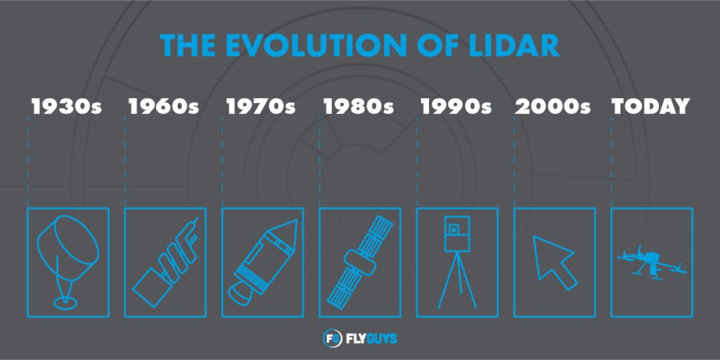
LiDAR through the years
LiDAR sensors may seem like recent technology; however, the concept has been around for decades. The development of and improvements to accuracy of the system have been relatively slow-moving.
Here we will look at the history of LiDAR and how it has evolved through the years.
Pre-LiDAR Days
Sonar, which gave us the ability to create sonic navigation ranging, is a predecessor of LiDAR. Sonar users sound waves to detect objects on or underwater, measure distances below water, and navigate through the water. The principles of sonar lead to the creation of Radar, or radio detection and ranging systems, which accomplishes the same thing more accurately using radio waves.
With sonar and radar, humans could now detect things that were once undetectable – why couldn’t it be done in the visual space also?
Cue the next step in detection advancement in using light from lasers for detection and ranging – LiDAR.

Humble Beginnings
In 1930, a man named E.H. Synge came up with the idea to measure how long it took for light to return to an emitter to find the distance of objects. At the time, Synge used searchlights to study the atmosphere, and in 1938 light pulses were used to measure the heights of clouds.
Over the next few decades, scientists continued experimenting with searchlights that reached heights of 43 miles into the atmosphere to help determine ozone distribution.

The 60s: LiDAR – it’s a gas!
Then in 1960, Theodore Maiman and his team at the Hughes Research Laboratory demonstrated the first laser – Ruby Laser – and one year later, the Hughes team built the first LiDAR prototype. This group brought the first commercial LiDAR to market in 1962.
The new technology gained traction quickly in the 1960s. Scientists Louis Smullin and Giorgio Fiocco were the first to shoot lasers to the moon to study its surface. The same scientists continued examining the atmosphere, reporting returns from 81 miles. Other atmospheric studies focused on fog, dust, haze, smog, clouds, steam, and pollen – weather phenomena that radar cannot see.

The 70s: Far out!
In 1971, LiDAR caught a ride into space for the first time on the Apollo 15. NASA used LiDAR sensors in their explorations for land mapping the surface of the moon, Mars, and Mercury. For the rest of the decade, the primary purpose of LiDAR was topographic mapping. Oceanographers and geologists used LiDAR to study the properties of ocean water, ice sheets, and canopies of forests.
At the tail end of the 70s, Johannes Riegl established RIEGL Laser Measurement Systems, which he used to build on technology he began working on in 1968. Also during this time, the federal government saw LiDAR advancements in defense applications such as targeting.
Slow and Steady
Up until this point, the development of LiDAR technology had been slow-moving. This was due to the lack of proficient and commercially available global positional systems, or GPS. To enable aerial sensor deployment, GPS technology is essential.

The 80s: Rad times for LiDAR
The 80s was the decade LiDAR finally came into its own. GPS solutions were becoming more advanced, and efficient satellite systems paved the way for aerial LiDAR deployment. Photogrammetry appeared on the scene when Ian Dowman introduced it to the discipline of map topography using satellite imagery. In 1985, a NASA team led by Bill Krabill trailblazed the use of GPS in maneuvering a flying aircraft. The team’s advancement would make airborne elevation mapping using LiDAR possible.

The 90s: Booyah!
Starting in the mid-90s, advancements in LiDAR upped its application game. The first commercial LiDAR with 2-25,000 pulses was manufactured and used for more accurate topographic mapping. Governments began using LiDAR to plan urban development as it helped determine the best locations to build infrastructure.
Areas previously undetected below the canopy, such as the Seattle Fault, were now being mapped using LiDAR flights. In 1998, Cyra Technologies introduced the first tripod-mounted 3D scanner and the first integrated point-cloud software.

The 2000s: Bling Bling
LiDAR continued to advance during the twenty-first century, and its applications in turn expanded. Companies were now collecting data with LiDAR for flood prevention, planning purposes, and development. These applications opened doors for the field of LiDAR archaeology.
In 2000, a team at the University of Texas at Austin led by James Gibeaut created the first LiDAR-based elevation model of an archeological site at Copan, Honduras. Staff from Cambridge University used LiDAR on the Loughcrew landscape in Ireland which discovered hundreds of new historical sites to study. Documentary filmmaker Steve Elkins used the help of the National Center for Airborne Laser Mapping (NCALM) to find ruins under the canopy of the Honduran Mosquitia rainforest. In another archaeology anecdote, the FlyGuys team discovered ancient pen walls from the 1850s once used for farming when deploying a LiDAR sensor in a client engagement.
In 2016, the U.S. Federal Aviation Administration (FAA) released the Small UAS rule which allowed the use of commercial drones weighing 55 pounds or less. This ruling made LiDAR-toting drones legal for commercial use in the U.S. One of the first commercial uses of LiDAR in the U.S. was to survey stretches of powerlines to detect invading vegetation.

LiDAR Today and Tomorrow
LiDAR sensors allow the collection of detailed and highly accurate elevation points. The system can produce point data within centimeter accuracy, validating the accuracy of LiDAR.
Today LiDAR applications are used across various professional industries because of the increased efficiency and reduced human cost compared to traditional measurement techniques. For instance, the technology is used in agriculture to help locate optimal sunlight for crop growth or to identify crops that require water and fertilizer.
LiDAR is used in oil and gas exploration due to its shorter wavelength. LiDAR can detect tiny molecules in the atmosphere, and a new method for locating new oil and gas deposits, called Differential Absorption LiDAR or DAL, is a recent development in LiDAR technology.
LiDAR continues to be an essential tool for studying climate change. It can be applied in natural catastrophe analysis, warning areas about impending tsunamis.
There are many other purposes for LiDAR, with more developing daily. Call FlyGuys today so you can be a part of the future of LiDAR.
Download LiDAR Report
Learn about LiDAR in this free download. Discover complete information on:
– How LiDAR works and what it’s used for
– How LiDAR helps further business objectives
– What sets FlyGuys’ LiDAR service apart