When Accuracy Matters
Whether relative or absolute, accuracy can vary greatly
In the world of drone mapping, accuracy is either relative or absolute. Both are essential in determining measurement accuracy, but other factors will dictate how much is needed. Intended outputs, the map use, and the decisions made from the mapped information will tell you how accurate the data needs to be.
Some projects require a high level of accuracy, while others may not. Though it seems evident that greater accuracy is always better, it is not always the case, depending on the project. Absolute accuracy is more time-consuming and costly, requiring heavier equipment and more advanced technology. So if relative accuracy can suffice, relative accuracy is as accurate as you need to be.
We will look at the two degrees of accuracy in-depth and discuss examples of when relative accuracy is acceptable over absolute. But before we get into it, let’s understand the meaning of survey-grade accuracy. When a project calls for survey-grade accuracy, the accuracy of the measurements must hold up in court for legal arbitration. Stamped by a licensed surveyor, survey-grade accuracy is typically needed for land development, drainage, or surveying floodplains. If any legal issues arise over land disputes that need to be settled in court, the drone mapping information must be highly accurate, thus the term survey grade.
Relative Accuracy
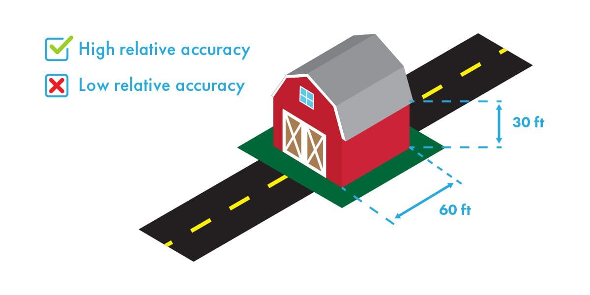
Relative accuracy is also known as local or internal. It is the degree to which a given point on a map is accurate relative to other points on the same map. If a distance between two points measures 20 inches in the real world, it measures 20 inches on the map.
Example
You are building your dream home, and the architect renders a 3D model of the plans. The measurement from the roof to the ground is 30 feet in the model. Once your house is built, if you were to measure the same point from the roof to the ground, it would measure 30 feet.
When relative accuracy is sufficient
Visual inspections and progress monitoring only need relative accuracy. Construction site inspections don’t require more than relatively accurate measurements, which is also suitable for monitoring crops in fields. Assessing areas after damage or 3D modeling for marketing purposes is fine with a level of relative accuracy. Measuring volume or length within a specific survey map requires relative accuracy.
If the data you collect from the drone will not be used to georeference a certain point in space, then you are good to go with relative accuracy.
How to attain qualified relative accuracy
GPS
Make sure the drone camera is calibrated correctly. Not only does calibration help to prevent crashes, but it also improves accuracy. The camera should be connected directly to GPS and synced to its clock to log location information simultaneously after each captured photo. Capture volumes of data and photos to avoid inconsistencies and minimize errors.
RTK
The addition of RTK or a real time kinematic module helps to improve GPS accuracy. RTK helps to correct errors and doesn’t rely on ground control. However, RTK needs a strong cellular connection between the base station and the module. If the project is on a large site or in a location with lousy cell service, RTK could become interrupted.
Absolute Accuracy
On the other hand, absolute accuracy, also known as global accuracy, is the degree to which a point on a map corresponds to a GPS coordinate in the real world. In other words, if someone needs to find the area of measurement somewhere in the world, your data must be absolutely accurate. A high level of absolute accuracy means that the latitude and longitude of a point on that map will correspond accurately with the actual GPS coordinates.
For example
You want to put a fence up in your backyard, so you need to know where your property line ends. You can look up the land survey conducted by the civil engineers who mapped the property before the neighborhood was developed. The engineering firm had to file the land survey for public records. No matter how long ago that title was filed, the absolute accuracy of the coordinates of your property line has not changed over time.
When you absolutely must have absolute accuracy
Professional surveys and overlays require absolute accuracy. Longitude and latitude coordinates and elevation measurements must be correct for the purposes of land development, so only global accuracy will suffice. This level of accuracy is also necessary when comparing multiple data sets from different time periods; for example, combining your map with geo-referencing or executing land title surveys. Design documents and environmental records for construction projects that can be called into question later must be backed up with absolute accurate coordinates. Overlays of geo-referenced site plans, such as surveying for floodplains, drainage and land development for new subdivisions, must have accurate coordinates.
What affects accuracy
A few factors affect the level of accuracy you can expect.
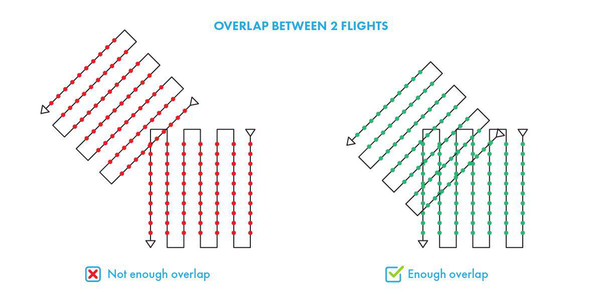
Image overlap
Photogrammetry is a method used to create 2D and 3D models by matching features from photos to form a dimensional model. To do this, the captured images must overlap significantly. The minimum required amount of overlap is 70 percent, meaning only one-third of the photos taken during a drone survey can reveal new features—the higher percentage of overlap you have, the higher level of accuracy.
To guarantee the captured images are aligned sufficiently, the drone should take off from a high point to cover more ground. If the drone takes off at a low point, it may fly too close to the ground causing the images to overlap poorly.
Resolution and Ground Sample Distance (GSD)
Ground sample distance is the real-world size of a pixel in the captured drone images. Most drone flights have a GSD between one and ten centimeters. A high GSD means a lower resolution, whereas a low GSD is a higher resolution. The better the resolution, the better the accuracy.
GSD is determined by three factors that alter the level of accuracy.
Resolution of the camera sensor
The lower megapixels a camera sensor has, the higher the GSD.
Altitude of flight
A drone flying at a high altitude results in high GSD, leading to lower accuracy.
Focal length or field of view of the camera
The wider the camera angle is, the higher GSD.
Flight Speed
How fast the drone is flying can determine the accuracy level—flying slower with a high shutter speed results in better accuracy.
How to obtain consistent accuracy
Ground control points, or GCPs, are marked points on the ground with a known geographic location. They increase the global accuracy of the map by locating your area of interest in the real world. In other words, they allow the longitude and latitude of your map to line up precisely with the actual GPS coordinates. Although they are vital tools for precision drone mapping, GCPs are not always necessary.
What level of accuracy do you need for your next project?
Whether you need relative or global accuracy, GCPs or RTK, FlyGuys has the solution for your drone mapping needs. Inquire about a quote today.