LiDAR vs. Sonar: What’s the Difference?
Based on our conventional understanding, the difference between these two sensor technologies seems obvious: LiDAR is used for land, and sonar is used for water. But LiDAR can also be used in underwater applications, which begs the question, which detection technology is best for your project?
This post will investigate LiDAR vs. sonar to explain the differences and similarities and the advantages and disadvantages of the two remote sensing techniques.
How they work
Think about the last time you heard your echo…cho…cho. An echo occurs when sound waves bounce off of close objects and returns to you. This natural phenomenon is the basic principle of both LiDAR and sonar. Both technologies transmit waves through pulses to detect objects. The returning pulses are then measured to determine speed and distance.
The main difference between these two sensors is the type of signal reflected off the object: LiDAR uses light pulses, and sonar uses sound waves. Both collect and analyze data that can be used to create imaging of the Earth, whether on land or below the surface of the water.
Round 1: LiDAR
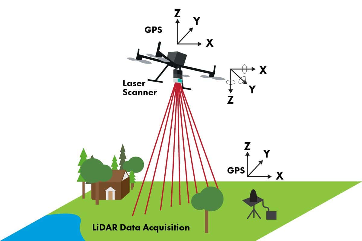
LiDAR, or li(ght) d(etection) a(nd) r(anging), is used to determine the distance between the light pulses and the object. These light pulses, when combined with GPS and other datapoints, generate precise, three-dimensional information about the shape of the Earth and its surface characteristics. LiDAR output is often used to create 3D maps. LiDAR laser pulses travel at the speed of light, thus increasing the speed and accuracy of the data collected. LiDAR can be used anywhere and can see through objects such as treetops and vegetation. LiDAR can even penetrate water, though not without limitations- more about that later.
The two types of LiDAR
Topographic LiDAR collects data aerially to calculate the elevation of landforms above sea level. It is one of the most accurate sensors for determining distance and digital imaging. Bathymetric LiDAR, or LiDAR used in sub-surface applications, helps calculate the depths of landforms below sea level. This LiDAR technique has limitations due to the characteristics of light’s interaction with water including refraction and light absorption.
Let’s take a closer look at bathymetric LiDAR.
Advantages and disadvantages of LiDAR underwater
The ocean is vast and mysterious. It is rarely explored because of its depth, lack of oxygen, and visibility. Bathymetric LiDAR makes expeditions to the ocean bottom, which are traditionally costly and dangerous, more attainable. There are drawbacks to this approach. Once light penetrates the water, it loses power, and the deeper the laser travels, the more power it loses. Light pulses do not travel through water easily, so the roundtrip to the object and back may not translate the most accurate data.
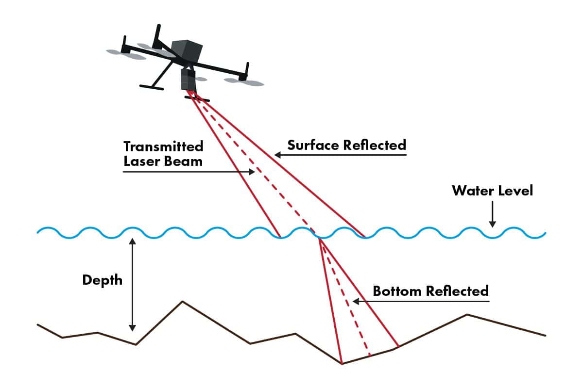
Another issue with obtaining accurate data is refraction, which happens when the water bends the light. Other factors including the turbidity of the water may hinder the results as the LiDAR signal may not reach the bottom of the surface.
So, what is the best alternative to LiDAR for underwater surveying?
Download LiDAR Report
Learn about LiDAR in this free download. Discover complete information on:
- How LiDAR works and what it’s used for
- How LiDAR helps further business objectives
- What sets FlyGuys’ LiDAR service apart

Round 2: Sonar
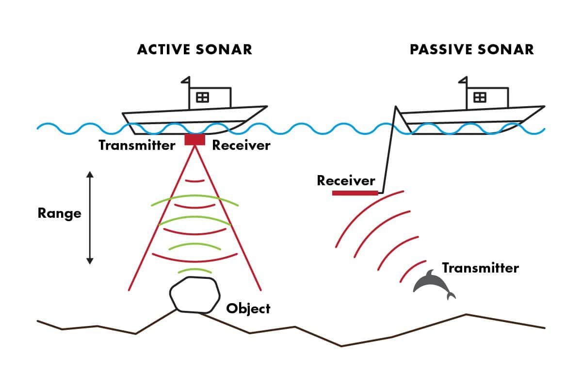
Sonar, or so(und) n(avigation) a(nd) r(adar), is like LiDAR in that it uses signal pulses to detect distance, but the transmitted signal is composed of sound waves rather than light pulses. Similar to how dolphins communicate using echolocation, sonar waves reflect off an object, bounce back to the sensor, and the data is then used to determine distance. Sound travels through water better than light, and can more easily reach the bottom of the ocean floor.
The Two Types of sonar
Just as there are two different types of LiDAR, there are also two types of sonar.
Passive sonar utilizes sensors that listen for any sounds coming from the depths of the water. When an object or sea creature emits sound waves, the sensor analyzes it to determine the type of source the sound came from.
Active sonar emits sound waves, and a receptor waits for them to reflect from objects. By calculating the time it takes for the sound wave to return to the receptor, the distance to the object can be estimated.
Advantages and disadvantages of sonar
Sonar is one of the few technologies that work efficiently underwater and is comparatively affordable. Long-distance communication and the speed of the sound waves allow sonar to be extremely useful for seafloor imaging. But, because of the noise and interference sound waves produce, there are risks to marine life. In addition, background noise and other errant sound waves often interfere with the accuracy of the data.
And the winner is….
It truly depends on the scope of your project. LiDAR will deliver more accurate results in shallow or clear-water settings, but users will generally face obstacles that reduce accuracy. Sonar is designed for underwater applications, however, in good conditions, the data collected isn’t as accurate as LiDAR and has the potential to disturb sea life.
Contact FlyGuys today to discuss bathymetric LiDAR and evaluate its suitability for your underwater data collection project.
More on LiDAR:
LiDAR vs RADAR: What’s the Difference?
Advantages and Disadvantages of LiDAR
What Can LiDAR Data Be Used For?
How UAV LiDAR Can Save You Money
Uses for LiDAR in Agriculture
5 Industry Use Cases for LiDAR
How LiDAR Technology Helps Archaeologists
Aerial Photogrammetry vs. LiDAR