LiDAR Transforms Urban Development Mapping: Insights from a Client Perspective
LiDAR technology has emerged as a game-changer in urban development and 3D mapping, revolutionizing how construction and engineering firms approach their projects. Among those harnessing the power of LiDAR is Smith & Jones Construction Solutions (SJCS). Led by owner Donald Jones, the company has embraced LiDAR to enhance its surveying and mapping capabilities and improve project outcomes. We spoke to Jones, who shared valuable insights and experiences. He shed light on the impact LiDAR technology has had on the company and the industry as a whole. His perspective unveils the case for LiDAR and how the technology has transformed their approach to urban development and 3D mapping, pushing boundaries and setting new industry standards.
Transforming Mapping Capabilities and Driving Efficiency: The Impact of LiDAR
“Incorporating LiDAR technology has revolutionized our mapping capabilities for urban development projects,” asserts Jones, highlighting the transformative effect of LiDAR on their operations. With LiDAR’s advanced capabilities, SJCS has experienced a paradigm shift in its approach to mapping, enabling them to achieve unprecedented levels of accuracy and precision.
Jones explains, “Before LiDAR, mapping was done mainly using traditional surveying methods, which were slow, labor-intensive, and often resulted in less accurate data. Surveyors would use tools like theodolites and total stations to measure angles and distances to various points on the ground. This process was time-consuming and could take months or even years to complete, depending on the size of the area being mapped. Traditional surveying methods could also be limited by terrain and weather conditions, which made it difficult or even impossible to collect data in certain areas.”
Integrating LiDAR has significantly improved the accuracy and precision of surveys and planning at SJCS, empowering them to elevate the quality of their deliverables. Jones states, “LiDAR has enabled us to achieve great levels of accuracy that surpass what was previously attainable with traditional methods that allow us to make confident and informed decisions, ensuring our projects are built on solid foundations.”
One of the most notable advantages SJCS has witnessed since implementing LiDAR is the substantial time and cost efficiency it offers. The technology’s ability to rapidly capture detailed data has revolutionized surveying and planning processes, translating into tangible benefits for SJCS and its clients. Jones elaborates, “LiDAR has brought significant time and cost savings to our projects. The speed at which we can collect data and create accurate maps has streamlined our workflows, reducing project timelines and enabling us to allocate resources more effectively. This efficiency translates into cost savings for our clients, which optimizes their investment.”
By leveraging LiDAR, SJCS has successfully streamlined its operations, delivering projects with heightened precision, reduced timelines, and improved cost-effectiveness, “a win-win for our clients and us,” boasts Jones. “Incorporating this cutting-edge technology will solidify a company’s position as an industry leader. It is raising the bar for mapping capabilities in urban development.”
Case Study – Skyline Plaza Project*
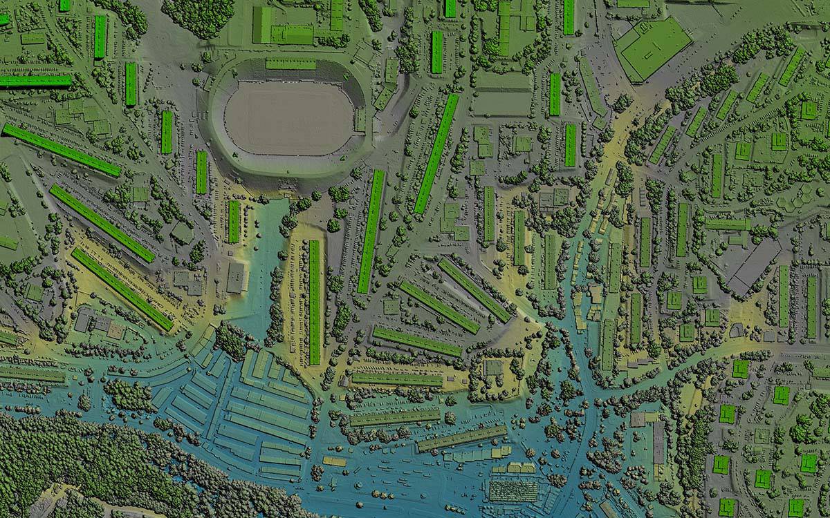
LiDAR technology extends beyond efficiency gains, as Jones recalls its pivotal role in his company’s Skyline Plaza project. Jones elaborates on how LiDAR’s capabilities enabled them to capture precise data on existing structures, terrain, and vegetation, revamping their approach to site analysis and project planning.
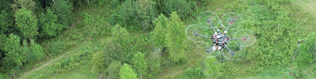
LiDAR sensors, mounted on drones, emitted laser pulses that accurately measured the distance to objects on the site. This process enabled the team to capture many data points, generating a highly accurate and detailed 3D point cloud representation of the project area.
The comprehensive understanding of the site derived from LiDAR data was instrumental in planning Skyline Plaza. Jones emphasizes, “LiDAR gave us a complete picture of the existing lay of the land. This allowed us to identify potential challenges beforehand, such as obstructions or terrain complexities, and develop appropriate strategies to address them.”
The detailed information captured by LiDAR facilitated efficient project planning, as the team at SJCS could visualize the project area in exceptional detail. This not only enabled them to identify potential clashes between new construction and existing structures but also aided in optimizing the placement of new elements within the site. By having a precise understanding of the topography and existing features, SJCS could create accurate digital terrain models and perform advanced simulations, leading to more informed decision-making.
Furthermore, the LiDAR data provided valuable insights into vegetation patterns and densities, allowing SJCS to devise strategies for vegetation management and preservation. Jones adds, “By analyzing the LiDAR data, we could assess the impact of the project on the surrounding environment and design appropriate measures to minimize ecological disruption.”
Using LiDAR data for the Skyline Plaza project resulted in a significantly smoother execution of the development. By identifying potential challenges early in the planning phase, SJCS could proactively address them, avoiding costly surprises and delays during the construction process. This proactive approach improved project timelines, reduced construction conflicts, and enhanced overall project efficiency.
Jones concludes, “The level of precision and insight LiDAR provided for the Skyline Plaza project was remarkable. It allowed us to plan with accuracy and foresight, resulting in a successful and seamless execution. LiDAR has undeniably become an indispensable tool in our urban development projects, elevating our capabilities and delivering superior outcomes.”
Overcoming Challenges and Maximizing Potential: Navigating the Path to LiDAR Adoption
While adopting LiDAR technology has brought numerous advantages, it hasn’t been without its challenges. Jones acknowledges the initial hurdles they faced, including the cost of implementing LiDAR. However, his team demonstrated resourcefulness in overcoming these obstacles, allowing them to harness the potential of the transformative platform.
One of the primary challenges clients encounter when considering LiDAR adoption is cost. LiDAR equipment, software, and data processing can be expensive. Jones reflects on this challenge, stating, “We initially recognized that LiDAR technology cost could pose a barrier. But we were determined to overcome that challenge because we understood the immense benefits of LiDAR.”
In addition to cost considerations, another challenge clients may face when deciding to use LiDAR is the complexity of processing and analyzing large LiDAR datasets. Jones admits, “Working with large-scale LiDAR datasets and extracting meaningful insights from them can be daunting. It requires specialized skills and knowledge.”
To address both challenges, SJCS pursued a strategic partnership with FlyGuys, a nationwide drone services provider specializing in LiDAR data collection and processing. This collaboration proved instrumental in ensuring SJCS had access to the necessary resources without incurring exorbitant upfront costs. By leveraging FlyGuys’ expertise and infrastructure, SJCS could leverage LiDAR technology and unlock its full potential without compromising its financial stability.
Jones reflects on their journey, stating, “While there were challenges along the way, the benefits of LiDAR technology far outweighed the initial obstacles we faced.” By recognizing and addressing the challenges head-on, companies like SJCS can navigate the path to LiDAR adoption and unlock its immense potential. While cost considerations and data complexity may pose initial hurdles, strategic partnerships, skill development, and collaboration with LiDAR specialists can empower clients to overcome these challenges and embrace the transformative benefits of LiDAR technology.
Embracing the future of LiDAR
LiDAR technology is poised to have a transformative impact on the future of urban development. To remain competitive in this evolving landscape, companies must stay up-to-date with LiDAR technology and incorporate it into their operations. Whether investing in LiDAR equipment and software or developing partnerships with LiDAR specialists, companies must embrace LiDAR. Companies like SJCS, who are early adopters of LiDAR technology, have already seen a significant competitive advantage in terms of efficiency, precision, and cost-effectiveness. Jones advises that by adopting LiDAR, companies can elevate their mapping capabilities, push boundaries, and set new industry standards.
Are you ready to become a leader in your industry? Contact Jessica today to learn more about how LiDAR can change the way you do business.
*Not the real name of a case study.