Have you ever wanted to gain insights into the work and expertise of a LiDAR drone pilot to learn about LiDAR technology and its applications in the real world? We spoke with our seasoned FlyGuys LiDAR pilot Zack, who shared his experiences and knowledge. During our conversation, we discussed LiDAR technology and its limitations. We also discussed the types of jobs LiDAR drones are used for, the latest capabilities of LiDAR, potential risks and challenges, and the process of a typical LiDAR job. Let’s dive deep into LiDAR from a pilot’s perspective.
LiDAR, or Light Detection and Ranging, is a remote sensing technology that uses laser light to measure and create a detailed 3D representation of the environment. “Think of it as similar to radar, but instead of radio waves, it uses laser beams,” Zack explains. “LiDAR systems emit laser pulses that bounce off objects and return to the sensor, allowing it to measure the distance, shape, and other characteristics of objects. Unlike photogrammetry, which captures images of an object, LiDAR works by scanning the object from different angles, producing a point cloud that can be transformed into a 3D model.”
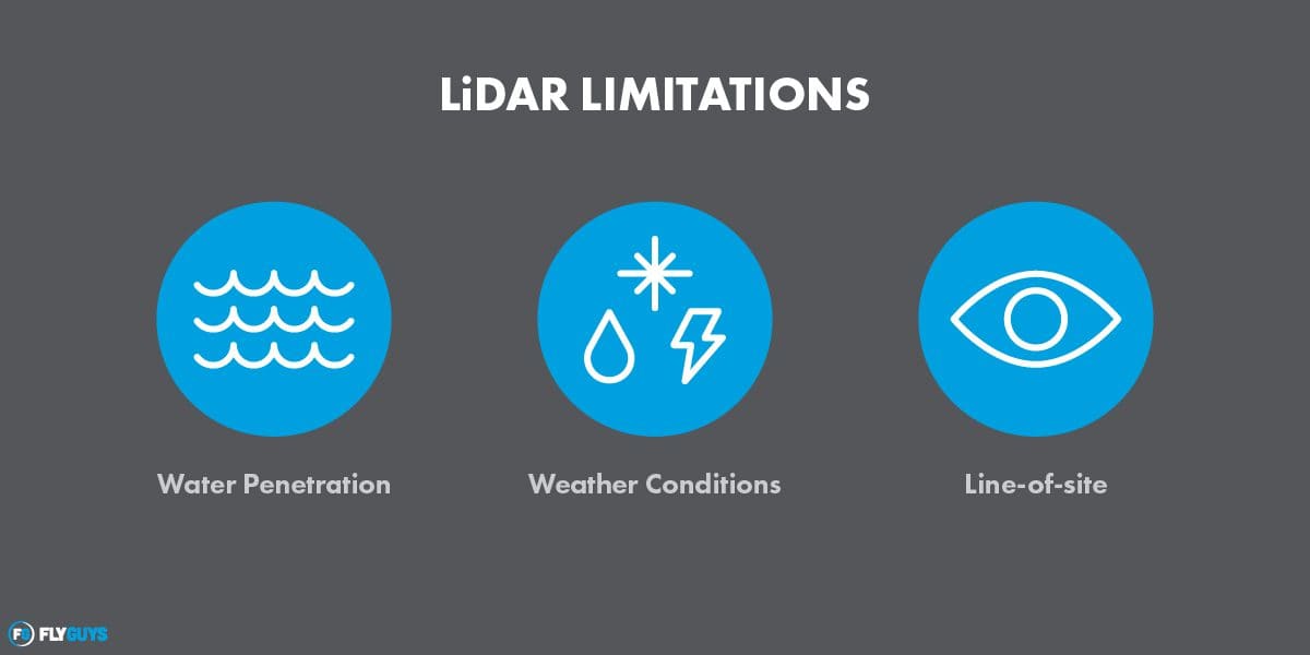
LiDAR Limitations
Zack makes no bones about the powerful technology, admitting that “while LiDAR technology is powerful, there are some limitations to consider. For example, LiDAR cannot penetrate water, making it a dead zone. If there is water on the property or if it’s flooded, LiDAR cannot provide elevation data for that area.” Additionally, weather conditions can impact the effectiveness of LiDAR. Flying in the rain is not always possible, so if it’s a particularly wet day, collecting data may not be possible. Similarly, snow and ice can also cause issues. The laser beam can reflect off snow or ice and cause elevation measurement errors.
Vegetation and foliage can also interfere with LiDAR scans as the laser beam bounces off leaves and branches, leading to incomplete or inaccurate data. LiDAR is limited to line-of-sight measurements. This means that obstacles blocking the laser beam’s path, such as buildings or mountains, may not be able to collect data beyond those obstacles.
LiDAR Advancements
The most recent advancement of LiDAR is the development of more compact, lighter, and more battery-efficient drones and scanners. Zack explains that when he started flying in 2021, the M600 had six motors and six batteries and weighed 22 pounds. The LiDAR scanner weighed 13 pounds on top of that. “The current M300 has only four motors and weighs eight pounds, and the LiDAR scanner only weighs five pounds. It is also more efficient. Additionally, the software is becoming more efficient, allowing for more accurate data collection.”
Real-Life LiDAR Jobs
Our pilot has been flying LiDAR for two years and has completed many different types of jobs requiring the technology. “One of the most common jobs is predevelopment before construction,” Zack tells us. LiDAR technology is widely used in predevelopment construction sites for accurate site mapping and surveying. The technology allows for the collection of precise data points, enabling engineers and architects to make informed decisions about site design and construction planning. By creating a detailed 3D model of the site, LiDAR can help identify potential obstacles. It can also provide insights into drainage, topography, and other critical site characteristics. “For example, a warehouse might need elevation data to know what to remove or add before laying down foundations.” Another job might involve scanning a long stretch of train tracks, as in the case of an 8-mile high-resolution scan. “That data can be used for corridor mapping or track measurement without disrupting the train schedule.”
LiDAR Challenges
While LiDAR technology offers many benefits and numerous applications, it is not without its risks and challenges. From Zack’s perspective, one of the main challenges associated with LiDAR is that it is not waterproof. This means that flying in rainy weather can be a hazard. “Water droplets can interfere with the laser beams,” he notes. “This leads to inaccuracies and errors in the data collected.”
Another challenge associated with LiDAR is airspace restrictions. In certain areas, drones are not allowed to fly due to safety and security concerns. This can limit the range of areas that can be scanned and can require additional planning and coordination to obtain the necessary permits and approvals for LiDAR flights.
Furthermore, LiDAR data collection can be impacted by environmental factors such as fog or smoke, which can reduce visibility and the accuracy of the scan. This can make it difficult to obtain the desired level of detail for certain applications.
To mitigate these risks and challenges, LiDAR pilots must carefully plan their flights and coordinate with local authorities and weather forecasts to collect safe and accurate data. They may also need to invest in specialized equipment or software to enhance the accuracy and reliability of their scans, such as moisture-resistant sensors or post-processing algorithms that filter out interference from rain or other environmental factors.
A Day on the Job for a LiDAR Pilot
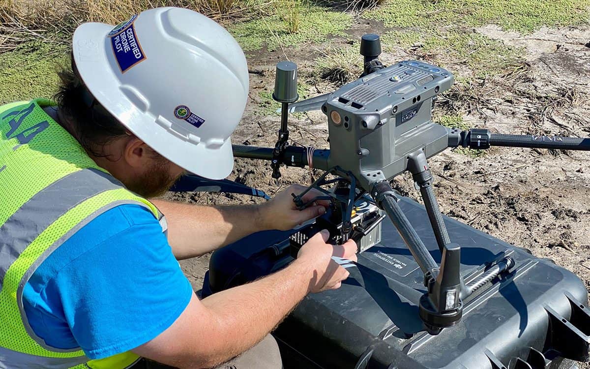
LiDAR jobs require certain equipment. First is the LiDAR scanner, which is mounted on a drone. A base station is also necessary to log GPS data that pairs with the data collected by the LiDAR scanner. In addition, black and white targets are used to align and calibrate the data, and a rover is used to verify the accuracy of the targets and the LiDAR data. Finally, software is required to process and analyze the data collected during the LiDAR scanning process.
Zack walks us through a typical day in the life of a LiDAR pilot. “A typical LiDAR job begins by finding an open space to set up a base station to log GPS data. Once the base station is established, I set up the targets to align horizontally. Then the entire site is flown, usually just under 200 feet. Once the site is scanned, the rover checks the targets for accuracy and verifies the LiDAR data after scanning and a base file is created. The logged data is then sent to FlyGuys’ LiDAR Mission Coordinator, Matthew, who is in charge of the software. One job usually takes all day because setting up the base station and logging data can take up to four hours. And you also have to consider travel to and from the job site.”
In terms of the data collected, LiDAR can collect elevation data, 3D scans, and scans from multiple directions to create a 3D model. Depending on the job, the data collected may vary. “For instance, on one mission, I scanned a dam to create a digital 3D model. It was important for me to consider the specific features that had to be captured accurately, like the height and thickness of the dam, the angle and shape of the slope, and any unique design elements or structures on the surface. I had to scan from multiple angles to ensure a comprehensive 3D model could be created. It was also important to consider the surrounding environment, including water levels and any vegetation or nearby structures to accurately capture the dam’s context and ensure seamless integration into larger models or simulations.”
LiDAR is a powerful remote sensing technology that has many applications, from predevelopment work to surveying train tracks. While there are limitations to consider, the technology is becoming more compact and efficient, making it easier to collect accurate data. As LiDAR technology continues to develop, it will be interesting to see how it is applied to different industries and what new capabilities are discovered.
To see if you have a project we can help you with, contact us today!