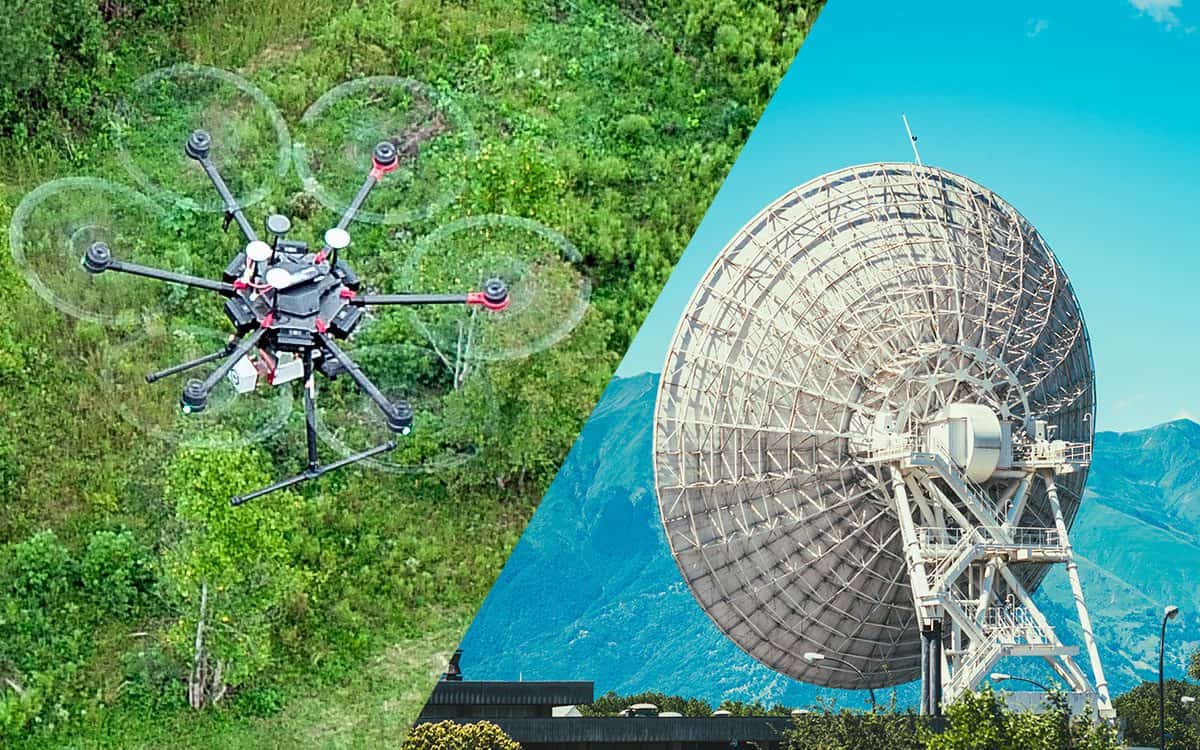
LiDAR vs RADAR: What’s the Difference?
LiDAR and Radar provide results in notably different ways
LiDAR and radar sensors are used for similar purposes, but there are some key differences between the two that make one better than the other depending on your situation. Let’s look at the basics of each technology and how they differ from one another to help you make an informed decision about what type of sensor will work best for you.
Essentially, Radar and LiDAR work towards the same goal: to detect objects. But these technologies operate and provide results in notably different ways.
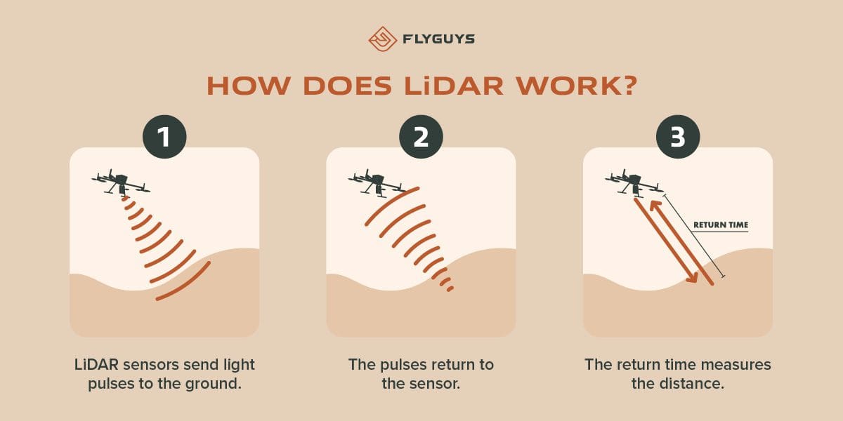
So, how does LiDAR work?
LiDAR, or Light Detection and Ranging, uses light to measure distance. It works by emitting a laser beam and measuring the time it takes for the beam to bounce back after it hits an object. The light beams repeatedly pulse in various directions in a specific area. Once the lasers meet a surface and return to the sensor, data points are logged. These points combine with GPS data and inertial measurement (IMU) to generate a digital point cloud.
A LiDAR system provides high-resolution, accurate data about an object’s shape, size, and location, which can be used to create digital twins, 3D mapping and surveying, and many other applications.
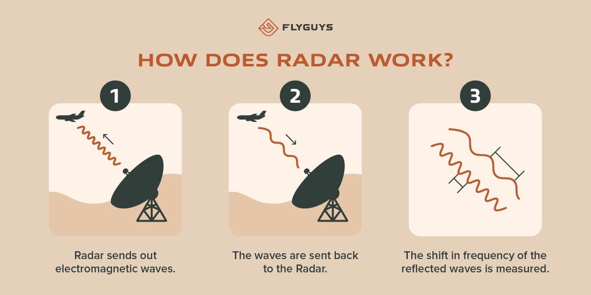
And how does Radar work?
Radar, or radio detection and ranging, works by emitting radio waves and measuring the time it takes for them to bounce back after hitting an object. It’s a form of active sensing that uses electromagnetic waves to determine an object’s range, angle, or velocity (speed) by measuring the shift in frequency of the reflected waves.
Radar can be used in various applications including air and sea navigation, weather monitoring, aircraft avoidance, remote sensing and geophysical surveys.
The differences between LiDAR and radar
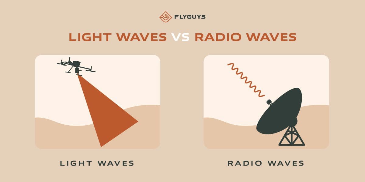
At the basic level, radar and LiDAR differ because they don’t use the same wavelength type. Here we will discuss wavelengths and other ways these two sensors are different.
Differences in light and radio wavelengths
The number one key difference between LiDAR and radar is the type of electromagnetic wave they emit.
LiDAR uses light waves, or lasers and radar uses radio waves.
LiDAR systems use light from pulsed laser beams with a wavelength in the near-infrared (NIR) range. Radar systems use microwaves and operate at much longer wavelengths. Unlike radar, LiDAR doesn’t measure how long it takes for the pulse to return (its “range”). Instead, it measures how far away an object is based on how much time passes before the reflected light returns to the sensor.
LiDAR technology has advanced considerably since the first laser was used to measure distances from remote sensors in 1968. The speed at which LiDAR can record data sets is limited only by how quickly its laser can turn on and off. This is also limited by how fast the scanner moves as it records data points.
Radar systems are often used on aircraft to survey large areas quickly. The amount of detail that can be captured depends on how frequently the system records data points and how fast it moves during flight.
Differences in their structure and operation
Land-based and airborne LiDAR systems use a digital camera or other imaging sensors to capture the reflected light from a laser beam. The data collected by the sensor is then processed into a point cloud, which can be used for creating digital maps and other applications.
In contrast, in radar systems the reflected microwaves are converted into an image on a screen or computer monitor. Radar can’t measure distance as precisely as LiDAR because it cannot know how far away an object is based on its reflection of energy.
Another difference is the range at which the two technologies can operate. LiDAR systems typically have a shorter range than radar systems but can provide much more precise measurements at close range. Radar systems, on the other hand, have a longer range and are better at detecting objects that are farther away.
LiDAR is also more expensive and requires a clear line of sight, while radar can detect objects through fog, rain, and other obstacles.
Differences in Use Case
LiDAR is primarily used for mapping and surveying. In these applications, LiDAR provides a 3D map of the world around it, which can be manipulated to create accurate models of objects or terrain. Radar is instead used for object detection and tracking. This means that radar sends out waves from a transmitter and waits for them to bounce off nearby objects. This returns information about their size, shape and distance from the transmitter. Radar does not produce an exact representation of its surroundings like LiDAR does; rather it produces 2D images similar in nature to those seen on television weather reports or military surveillance systems.
LiDAR is often used in applications such as self-driving cars, mapping, and surveying, while radar is commonly used in weather forecasting, air traffic control, and military applications.
Why do these differences matter?
The different wavelengths return different kinds of results. Since radar wavelengths are larger, their returned results aren’t as detailed as LiDAR sensors. LiDAR has higher resolution and can provide more detailed and accurate measurements than radar.
LiDAR is generally more accurate than radar because it uses laser light, which has a very short wavelength and is, therefore, able to provide more precise measurements. However, the accuracy of a LiDAR system depends on several factors, including the laser’s quality, the scanner’s design, and environmental conditions.
On the other hand, the accuracy of a radar system depends on the frequency of the radio waves it uses, the antenna design, and the system’s processing power. Radar can also be affected by atmospheric conditions, such as rain or snow, which can absorb or scatter radio waves and reduce the accuracy of measurements.
In general, LiDAR is considered to be more accurate than radar, especially at short ranges. However, radar has the advantage of being able to operate in a wider range of environmental conditions and at longer ranges. It is also generally less expensive to produce and implement than LiDAR.
Download LiDAR Report
Learn about LiDAR in this free download. Discover complete information on:
- How LiDAR works and what it’s used for
- How LiDAR helps further business objectives
- What sets FlyGuys’ LiDAR service apart

While both LiDAR and Radar sensors have their pros and cons, LiDAR is a much more accurate technology.
In principle, LiDAR is a much more accurate technology than radar. LiDAR can detect objects that are small and far away. It can also be used to map the terrain and detect objects in real-time.
If you want to detect larger objects, especially moving ones, radar is a possible choice. For generating more finely detailed 3D models of static environments with clearer analysis of topography and object contours, LiDAR is the way to go.
LiDAR offers better accuracy through its laser-based approach to capturing data, which allows it to measure distance with greater precision than radar. In fact, the resolution of LiDAR is 10x better than that of radar sensors—and it’s more precise than any other sensor on the market today (including cameras). As such, it is used for mapping and navigation applications where high accuracy is necessary.
Radar has its own advantages over LiDAR when it comes to object detection in motion. While radar can’t perceive objects as precisely as LiDAR does at long distances, it does use sound waves instead of light waves when detecting objects near or on top of moving vehicles—which means that radar can detect obstacles up close that are moving fast enough not to be captured by cameras but not fast enough for lasers to pick up correctly.
So which technology is better for me? LiDAR or radar?
LiDAR is a much more accurate technology, which makes it the ideal choice for many applications. It also has the ability to measure distance over time, which means it can create 3D models of objects and environments. However, there are some downsides to LiDAR, including its high cost and difficulty in manufacturing. Radar sensors have lower accuracy, but they’re less expensive than LiDAR systems and don’t require line-of-sight like some other technologies.
It all boils down to the type of project you are working on. This will determine which sensor technology is right for you.
Applications radar is generally used for:
- Air traffic control
- Astronomy
- Aircraft anti-collision systems
- Tracking and detecting ships at sea
- Measuring automobile speed
- Weather observation
Applications LiDAR is generally used for:
- Surveying
- Archaeology
- Architecture
- Construction or industrial site inspections
- Agriculture
- Oil and gas exploration
- Forest planning
- Flood Modeling
- Transport planning
Call FlyGuys for LiDAR Remote Sensing Services
Call 1 (888) 837-0940 or fill out a contact form below when you need expert LiDAR services. We offer a nationwide network of licensed and insured drone pilots who can help you with LiDAR remote sensing data collection. We are experienced in many different applications and are ready to assist in your project by providing data that helps you make informed decisions.
Get A Quote
Take Your Project To New Heights
Whether the project takes us to a major metropolitan city, a mid-sized town, or a rural area far away from civilization, we’re ready to deploy FAA-certified pilots and follow stringent safety measures. Connect with FlyGuys for a quote, and let’s explore the right solution for you.
Please note that we are currently unable to assist in the search for missing pets. This limitation is due to the specific challenges and regulations associated with using drones for such purposes.