Drone Mapping vs. Traditional Surveying for Large Sites
For large sites, drone mapping captures existing conditions faster and in more detail than a ground crew, usually collecting data in a few days instead of a week or more. However, traditional surveying is still required for legal boundaries, survey control, and sub-centimeter-level work. For the best outcome in data collection, large-site workflows use both ground control set by a licensed surveyor and dense data captured from the air.
If you manage a 300-acre solar site, a highway corridor, or a multi-phase development, the debate isn’t “Do we use a drone or surveyor?” Rather, the question to be answered is “Which method is needed for each part of the job, and how can we combine them without paying twice?”
This guide compares drone mapping, drone LiDAR, and traditional ground surveying on the factors that matter for large sites: speed, accuracy, coverage, safety, cost, and what each method legally can and can’t deliver.
How does drone mapping compare to traditional surveying?
Drone mapping gets points for speed, coverage, and data density. Traditional surveying scores on point-level precision, legal standing, and work under canopy or inside structures. The table below compares the three methods most large-site teams weigh.
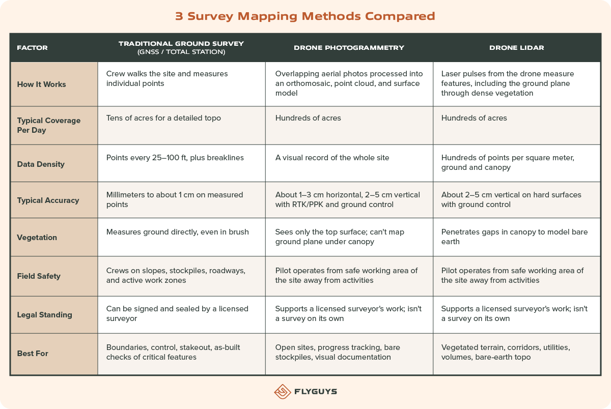
Accuracy ranges are typical, not guaranteed. Every project’s results depend on control, sensor, flight plan, terrain, and processing.
Why does speed matter more on large sites?
Ground survey time grows with acreage because a crew has to physically reach every point. Drone flights scale the capture of all points from the flight. On a 20-acre lot the difference is modest. On a 500-acre site, it can be the difference between one field day and two weeks of crew time.
That speed also changes what’s practical. When a full-site capture takes a day, teams can map monthly or weekly instead of once at the start and once at the end.

When is traditional surveying still the right call?
Traditional surveying is the right call whenever the deliverable needs a licensed surveyor’s signature or sub-centimeter precision. Drones don’t replace that work. They reduce how much of it a crew has to do by hand, and provides denser content of the site.
Keep a licensed surveyor in charge of:
- Boundary and property surveys, including ALTA/NSPS surveys and legal descriptions
- Survey control, the ground control points and checkpoints that tie drone data to a real coordinate system
- Construction stakeout and layout of critical features
- Sub-centimeter-level work, such as structural monitoring, rail, or precise as-built checks
- Features drones can’t see, like utilities in dense canopy, areas under bridges, or inside structures
- Any deliverable that must be signed and sealed under your state’s surveying laws
- Wetland delineation and SWPPP inspections are additional requirements that also require a certified individual.
Rules on who can produce “survey” deliverables vary by state. If a map or model will be used for design, permitting, or legal purposes, confirm the licensing requirement before the project starts.

How does LiDAR compare to traditional surveying?
Drone LiDAR gives large, vegetated sites a bare-earth terrain model in a fraction of the field time a ground crew needs. Ground surveying still provides tighter precision on individual points. For most large-site topo work, LiDAR handles the coverage and ground surveying handles control and verification of the flight.
What LiDAR does that a ground crew can’t do efficiently
A LiDAR sensor fires hundreds of thousands of laser pulses per second. Some pulses slip through gaps between leaves and branches and return from the ground. Processing separates those ground returns from vegetation, buildings, and other features.
That makes LiDAR the practical choice when:
- The site is wooded or overgrown. A ground crew can measure under canopy, but slowly. Photogrammetry can’t see the ground at all.
- The site is long and narrow. Transmission lines, pipelines, roads, and rail corridors stretch for miles.
- You need continuous terrain, not sampled points. Drainage design, flood studies, and earthwork balancing all depend on how well the surface between points is modeled.
- Access is hard or hazardous. Steep slopes, wetlands, active roadways, and energized infrastructure keep crews out of harm’s way.
Where traditional surveying still has the edge over LiDAR
- Point precision. A total station or GNSS rover on a known point is more precise than any single LiDAR return.
- Hard features and breaklines. Curbs, top and toe of slope, and inverts are often picked up faster and more precisely on the ground.
- Dense, low vegetation. Thick grass, crops, or brush can block most pulses and leave the bare-earth model with gaps.
- Control and checkpoints. LiDAR accuracy is only as good as the control it’s tied to and the checkpoints used to verify it.
LiDAR vs. traditional surveying at a glance
| Question | Drone LiDAR | Traditional ground survey |
| Can it map ground under trees? | Yes, through gaps in the canopy | Yes, point by point |
| How fast on 200+ acres? | Usually one to a few field days | Often one to several weeks |
| How precise on one point? | Centimeter level | Millimeter to centimeter level |
| How complete is the surface? | Continuous, millions of points | Sampled, with interpolation between points |
| Who signs the final deliverable? | A licensed surveyor, if required | A licensed surveyor |
Should you use drone photogrammetry or drone LiDAR?
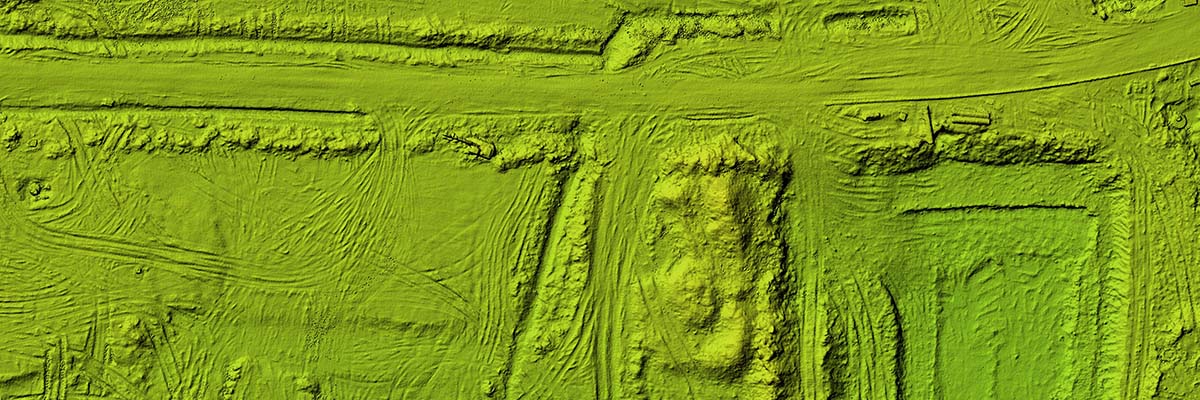
Use photogrammetry for open, mostly bare sites where a visual record matters. Use LiDAR when vegetation, or bare-earth terrain drive the project. Many large projects use both.
Choose photogrammetry when:
- The site is graded, paved, or sparsely vegetated
- You need an orthomosaic for planning, progress tracking, or stakeholder updates
- You’re measuring stockpile or earthwork volumes on exposed ground
- Budget is the main constraint, as photogrammetry generally costs less per acre
Choose LiDAR when:
- Trees, brush, or crops cover a meaningful part of the site
- You need a bare-earth terrain model for drainage, grading, or design
- Accuracy and precision are paramount for comparison or engineering
- You’re mapping power lines, poles, or other thin structures that photos capture poorly
Use both when you need bare-earth terrain and a high-resolution visual record of the same site. Capturing RGB imagery alongside LiDAR in one mobilization avoids a second site visit.

How do drone mapping and traditional surveying work together?
On large sites, the surveyor sets the accuracy and the drone supplies the coverage. Survey crews spend their time on control, checkpoints, and critical features, while the drone captures everything in between.
A typical combined workflow looks like this:
- Scope the deliverable. Agree on coordinate system, accuracy targets, and output formats before mobilization.
- Set control. The surveyor places and measures ground control points and independent checkpoints across the site.
- Fly the site. The drone pilot captures imagery, LiDAR, or both, following a flight plan built for the accuracy target.
- Process and check. Data is processed, tied to control, and tested against checkpoints that weren’t used in processing.
- Fill gaps on the ground. The crew picks up breaklines, hard features, and anything the drone couldn’t see.
- Review and certify. The licensed surveyor reviews the combined dataset and signs any deliverable that requires it.
The result is a denser, more complete dataset than a ground survey alone, delivered sooner, with the same professional accountability.
For more on proving accuracy, see How Accurate Is Drone Data and What Data Quality Standards Ensure You Can Trust It?

Is drone mapping cheaper than traditional surveying for large sites?
Usually, yes, and the savings grow with acreage. Ground survey cost scales with crew-days, while drone capture covers far more ground per day. On small sites, mobilization and processing can make the two methods cost about the same.
What drives the cost of drone mapping:
- Acreage and site shape. Larger, compact sites cost less per acre than small or irregular ones.
- Sensor. LiDAR costs more per acre than photogrammetry.
- Accuracy target. Tighter targets need more control, more overlap, and more QA.
- Deliverables. A raw point cloud costs less than a classified point cloud, contours, and CAD-ready surfaces.
- Repeat flights. Recurring captures on a set schedule often lower the per-flight price.
The bigger saving is often schedule. Field data that arrives days sooner lets design, estimating, and earthwork decisions start sooner. A complete surface model also cuts the risk of discovering a missed grade change after construction begins.

Where FlyGuys fits
FlyGuys captures the aerial data; licensed surveyors and engineers own the survey. Surveying and engineering firms across the U.S. bring FlyGuys in to collect drone LiDAR and imagery on sites their crews would otherwise spend weeks walking.
What FlyGuys provides:
- Nationwide drone pilots, FAA Part 107 certified, deployed to your site without the travel cost of sending your own crew
- Drone LiDAR and photogrammetry, including large-scale mapping for sites of varying scale.
- Data built for professional workflows, delivered in formats your survey and CAD teams already use.
- Repeatable capture across many sites, with the same flight standards and QA on every mission.
What FlyGuys doesn’t do: FlyGuys is not a state-licensed land surveying or professional engineering firm. Boundary surveys, signed and sealed deliverables, and survey control stay with your licensed professional. FlyGuys supports that work with the field data.
Learn more about drone LiDAR services and drone data for surveyors and mappers, or request a quote.
Frequently Asked Questions About Drone Mapping and Traditional Surveying
Is drone mapping as accurate as traditional surveying?
Not point for point. A ground survey measures individual points to millimeters or about a centimeter. Drone mapping with proper ground control typically reaches a few centimeters, but it measures the entire surface instead of samples. For most large-site topo, volume, and progress work, that accuracy is enough.
Can a drone survey replace a licensed land surveyor?
No. Drone data supports a licensed surveyor’s work but doesn’t replace it. Boundary surveys, legal descriptions, and signed and sealed deliverables require a licensed professional under state law.
Do drone maps need ground control points?
For survey-grade results, yes. RTK or PPK drones reduce how many control points you need, but independent checkpoints are still the way to prove accuracy. A licensed surveyor typically sets and measures them.
Can drone LiDAR see through trees?
Partly. LiDAR pulses pass through gaps in the canopy and return from the ground, so it can model bare earth under most tree cover. Very dense, low vegetation can still block enough pulses to leave gaps.