
Drone Inspection Services Compared: How to Choose the Right Provider
Choosing the right drone inspection service comes down to more than finding someone who can fly a drone. You need a provider that can collect the right data, meet your project requirements, and deliver information your team can actually use.
For a single inspection, a local drone pilot may be all you need. But when you’re managing dozens or hundreds of sites across multiple states, the process becomes more complicated. Scheduling, safety, data quality, and deliverables all need to be coordinated, regardless of where the work takes place.
So, how do you know which provider is right for your project?
This guide compares five types of drone inspection providers, explains six important factors to consider, and provides a checklist to help you evaluate your options.
What Do Drone Inspection Services Include?
Drone inspection services involve more than capturing aerial photos. Depending on the project, they may include flight planning, data collection, quality assurance, processing, and analysis.
Most drone inspection projects involve three main stages:
- Data capture: A certified drone pilot collects imagery or sensor data based on the asset and inspection requirements. This may include high-resolution RGB photos and video, thermal imagery, LiDAR point clouds, or overlapping images used to create orthomosaics and 3D models.
- Processing and quality assurance: Collected data is reviewed for coverage, image quality, overlap, and accuracy, where applicable. Depending on the deliverables, it may also be processed into mapping products or other usable formats. Ideally, issues like missing angles or incomplete coverage are identified before the pilot leaves the site.
- Deliverables and analysis: Data is organized and delivered in formats your team can use, such as annotated images, orthomosaics, point clouds, thermal reports, or inspection findings that feed into existing software and asset management systems.
Not every drone inspection provider handles all three stages.
Some specialize in data collection, while others focus on processing, analysis, or software. Managed providers may coordinate data capture and delivery while working alongside technology partners that handle specialized analysis.
Before choosing a provider, determine which parts of the process you need them to manage and which your team already has covered.
The 5 Types of Drone Inspection Providers, Compared
There isn’t one type of drone service provider that’s right for every project. A company inspecting a single commercial roof has different needs than a utility managing thousands of assets across multiple states.
Here’s how the five common provider models compare.
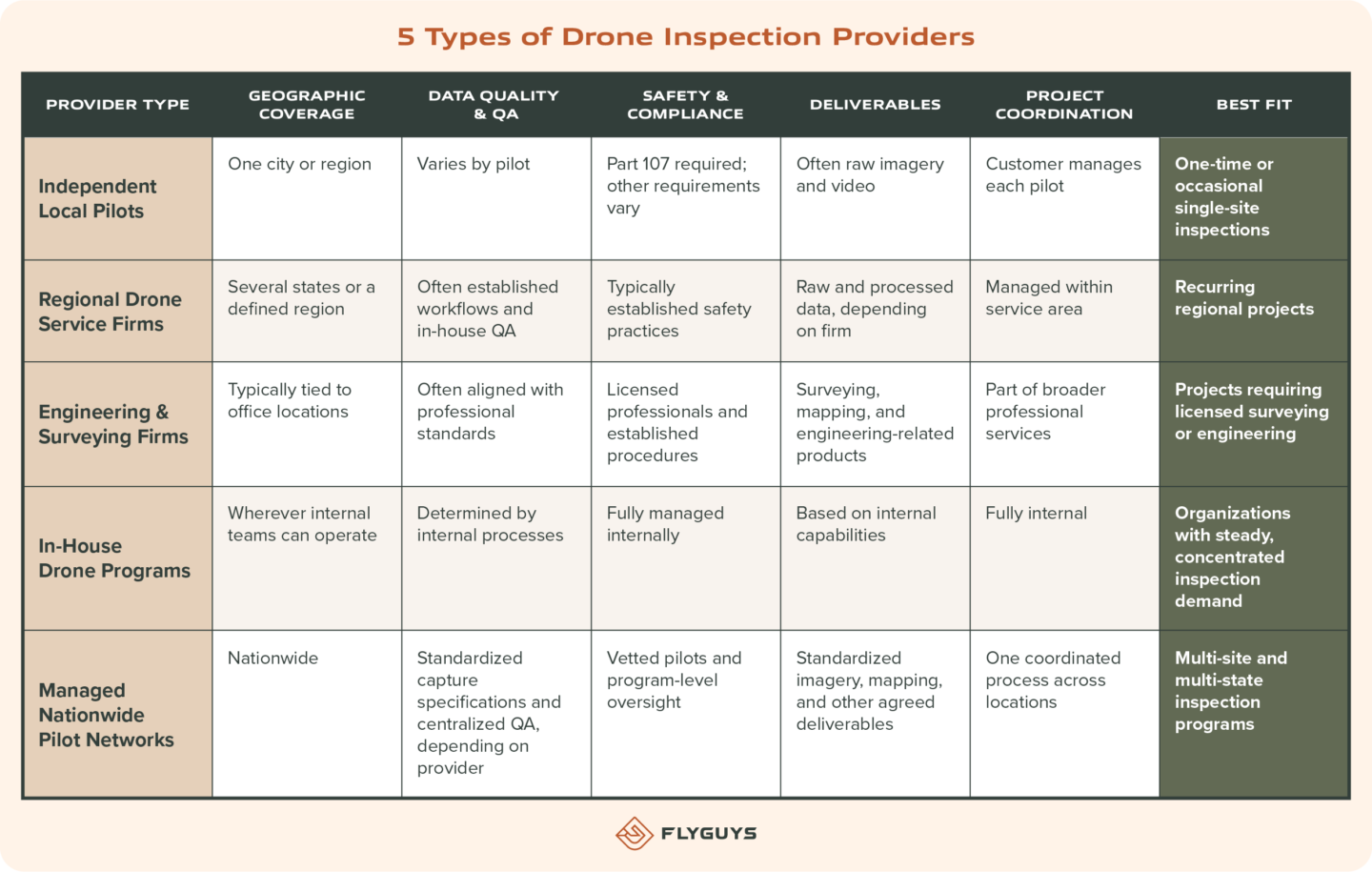
Independent Local Drone Pilots
For a one-time inspection, hiring a local FAA Part 107-certified pilot can be a practical, cost-effective option.
You can work directly with someone familiar with the area, coordinate the flight, and receive the imagery you need without involving a larger organization.
The challenge comes when you need to repeat that process across multiple locations.
Imagine hiring 50 different pilots to inspect 50 facilities. Without standardized requirements, you could receive different flight patterns, camera settings, image quality, and file structures. You’re also responsible for scheduling, insurance verification, and managing each vendor.
For occasional inspections, that may be manageable. For an ongoing program, it can become a significant administrative burden.
Regional Drone Service Firms
Regional drone companies typically offer more structure than independent pilots. Many have established crews, defined workflows, quality checks, and the ability to provide processed deliverables.
They’re often a good fit for organizations with recurring projects concentrated in one geographic area.
However, when projects expand beyond their service territory, you may need additional providers. That can mean managing different processes, pricing structures, and data standards.
Engineering and Surveying Firms With Drone Capabilities
Many engineering and land surveying firms use drones as part of their broader professional services.
These firms are particularly valuable when aerial data needs to support engineering analysis, surveying, or work requiring licensed professionals.
They may provide technical oversight, accuracy verification, and deliverables that meet specific engineering or surveying requirements.
However, if your project only requires routine visual documentation or thermal imagery across numerous sites, a full engineering engagement may involve more resources and cost than necessary.
In-House Drone Programs
Building an internal drone program gives organizations direct control over equipment, scheduling, data collection, and workflows.
For companies with frequent inspection needs and facilities concentrated near their teams, this approach can work well.
But it also comes with ongoing responsibilities. Companies must purchase and maintain equipment, train and certify pilots, manage insurance and airspace requirements, and establish internal processes to maintain data quality.
There’s also the question of capacity. Your team may be stretched thin during peak inspection periods and have limited work between cycles.
Managed Nationwide Drone Pilot Networks
A managed nationwide network combines local drone pilots with centralized project coordination, standardized capture requirements, and quality assurance.
Instead of sourcing individual pilots for every location, customers work through one provider that coordinates the work across their sites.
This model can be especially valuable for organizations managing inspections across multiple states, where consistent data and reliable scheduling matter just as much as geographic coverage.
For example, FlyGuys coordinates reality data collection through a nationwide network of Part 107-certified drone pilots. Customers can manage multi-site projects through one coordinated process rather than sourcing, scheduling, and managing individual pilots at each location.
The key is establishing clear capture requirements from the beginning so every pilot understands what data needs to be collected and how it should be delivered.
Managed networks typically focus on data capture and delivery, while licensed engineering conclusions or specialized analysis may be handled by the customer’s team or a technology partner.

6 Things to Look for in a Drone Inspection Provider
Once you’ve narrowed down the type of provider that makes sense for your project, it’s time to look at how they actually operate.
Here are six areas to evaluate before making a decision.
1. Geographic Coverage and Scheduling
Can the provider cover all your locations, including remote or rural sites? And how quickly can they get someone there?
For companies managing multiple facilities, geographic coverage can have a major impact on project timelines and costs.
Ask about typical lead times, how pilots are assigned, and what happens when weather or site conditions force a schedule change.
A provider that can coordinate work across your entire footprint can save your team from managing multiple vendors and separate schedules.
2. Data Quality and Consistency
Getting aerial imagery is one thing. Getting imagery that meets the same standards every time is another.
This becomes especially important when you’re comparing asset conditions or construction progress over time.
Look for a provider that establishes capture specifications before the first flight, including:
- Flight altitude and image overlap
- Camera angles and resolution
- Required asset views and coverage
- File naming and organization
- Accuracy requirements and ground control, when applicable
Ask how the data is reviewed before delivery and what happens if a capture doesn’t meet the agreed-upon requirements.
A defined quality assurance process and reflight policy can help prevent missing or unusable data from becoming your team’s problem.
3. Safety and Regulatory Compliance
Every commercial drone pilot operating under FAA Part 107 in the United States must hold a Remote Pilot Certificate.
But certification is only the starting point.
Depending on your project, pilots may also need airspace authorizations, waivers, appropriate insurance coverage, and training to meet site-specific safety requirements.
For utility and energy inspections, this could include personal protective equipment, site orientations, contractor prequalification, and protocols for working around energized equipment.
Ask how providers verify pilot credentials, manage airspace requirements, and ensure their pilots meet your company’s safety standards.
4. Deliverables That Work With Your Systems
What happens to the data after the flight?
Before signing with a provider, make sure you understand exactly what you’ll receive and how it will fit into your existing workflow.
Depending on the project, deliverables may include high-resolution imagery, thermal data, orthomosaics, point clouds, or processed inspection outputs.
Ask for samples and confirm file formats, organization, and compatibility with your inspection, GIS, or asset management platform.
The goal isn’t just to collect data. It’s to make sure your team can use it without spending additional time reorganizing or converting files.
5. Project Coordination and Visibility
Managing a single inspection is fairly straightforward. Managing 200 inspections across different locations, weather conditions, and schedules is a different story.
That’s why project coordination should be part of your evaluation.
Find out who manages scheduling, how your team communicates with the provider, and whether you can track progress throughout the project.
You should be able to answer questions like:
- Which sites are scheduled?
- Which inspections are complete?
- Is any data still going through quality checks?
- Which deliverables are ready?
Having one coordinated process and a clear point of contact can make a big difference when you’re managing a large program.
6. Enterprise Readiness
For larger organizations, a drone inspection provider needs to fit into existing business processes, not create new administrative work.
Ask how the provider handles data security, storage, ownership, contracts, and invoicing.
Can they work under your master services agreement? Can they provide reporting across an entire portfolio? How do they handle large volumes of data and multiple project stakeholders?
These details may not be as exciting as the technology, but they matter when you’re building a program that needs to operate consistently over time.

Choosing Drone Inspection Services by Industry and Use Case
Different industries use drone inspections for different reasons. Understanding your specific goals can help you prioritize the capabilities that matter most.
Construction Site Inspections
Construction teams use drone imagery to monitor progress, verify site conditions, document milestones, and maintain a visual record of a project.
Owners, general contractors, and lenders can use repeat captures to see how work is progressing, support draw inspections, and document conditions when questions or disputes arise.
For construction, consistency between flights matters most.
If a site is captured at different altitudes or camera angles each month, it becomes harder to compare changes over time.
Look for a provider that can establish repeatable flight plans and maintain a reliable capture schedule, whether you’re managing one active jobsite or projects across several states.
Energy Facility Inspections and Power Plant Maintenance
Energy facilities often rely on both visual and thermal inspections to evaluate equipment conditions.
Solar farms use thermal imagery to identify potential hot spots, failed cells, and string outages. Substations and power plants may require thermal and high-resolution visual data to evaluate equipment, structures, and stacks.
For these projects, timing and site conditions are critical.
Power plant maintenance may need to happen during a scheduled outage, leaving little flexibility for delays or repeat flights. Solar thermography also requires appropriate weather and irradiance conditions to collect useful thermal data.
When evaluating a provider, ask about sensor capabilities, experience with your asset type, scheduling around maintenance windows, and familiarity with your site’s safety requirements.
Utility Asset Management
Utilities manage assets across large service territories, from transmission and distribution lines to poles, structures, and surrounding vegetation.
Inspections are often recurring, with teams comparing asset conditions over time to identify changes, prioritize maintenance, and support internal or regulatory requirements.
For these programs, geographic coverage and standardized data collection are essential.
Each asset needs to be documented using consistent angles, naming conventions, and capture requirements so the data can be organized and incorporated into asset management or GIS systems.
A provider with pilots distributed across a service territory may also be able to inspect multiple circuits simultaneously rather than relying on a single traveling crew.
Infrastructure Portfolio Management
When you’re responsible for dozens or hundreds of properties, collecting data is only part of the challenge. You also need a consistent way to evaluate each location.
Standardized aerial documentation makes it easier to compare sites, share information with stakeholders, and support decisions across an entire portfolio.
Consider an economic development organization managing industrial properties across a large region.
Its team may need aerial photos and video to help prospective buyers or site selectors understand property conditions, access points, and surrounding infrastructure. That imagery can then be packaged alongside engineering and due diligence information.
Handling each site internally may work at first. But as the number of properties grows, coordinating travel, scheduling, and data collection can take valuable time away from other responsibilities.
A managed drone network can help by coordinating local pilots, maintaining consistent capture requirements, and delivering comparable documentation across the portfolio.
The result is a more repeatable process that helps stakeholders evaluate properties without requiring internal teams to travel to every location.
Drone Inspection Provider Checklist: 12 Questions to Ask Before Hiring
Before committing to a provider, ask a few questions to understand how they’ll manage your project.
These 12 questions can help you compare providers and identify potential gaps before work begins.
Coverage and Scheduling
- Can you cover every site on our list, including remote locations, using your own pilots or network?
- What is your typical lead time from request to flight, and how do you handle weather delays?
- Can you schedule inspections around fixed windows, such as planned outages or construction milestones?
Data Quality
- Will you provide written capture specifications for each asset type before work begins?
- How is data reviewed before delivery, and what happens if a flight doesn’t meet the requirements?
- What level of accuracy should we expect, and how is it verified?
Safety and Compliance
- Are all pilots FAA Part 107-certified, and how do you manage airspace authorizations and waivers?
- What insurance coverage do you carry, and can your pilots meet our site-safety and contractor prequalification requirements?
Deliverables and Data
- Can you provide sample deliverables in formats compatible with our inspection or GIS platform?
- Who owns the data, where is it stored, and how is it secured?
Program Management
- Who will be our main point of contact, and how can we track the status of each site?
- Can you work under our master services agreement, and how do you handle invoicing and program-level reporting?

Red Flags to Watch for When Hiring a Drone Inspection Provider
A provider may have experienced pilots and impressive equipment, but that doesn’t necessarily mean they’re equipped to manage your inspection program.
Here are a few warning signs worth paying attention to:
- No documented capture requirements. Without clear standards for how each asset should be documented, data can vary from one inspection to the next.
- No defined quality assurance process. Ask how data is reviewed and what happens if an inspection is incomplete or doesn’t meet specifications.
- Unclear data ownership. Your contract should explain who owns the imagery, how it’s stored, and how long it’s retained.
- Inconsistent pilot requirements. Different equipment, settings, and file structures can make it difficult to compare data across multiple sites.
- Vague answers about insurance or safety. A qualified provider should be able to explain its safety processes and provide appropriate documentation.
- Deliverables that don’t fit your workflow. If the sample data requires extensive reformatting before your team can use it, that could become an ongoing challenge.
Ultimately, you’re looking for a provider that can explain not only how it collects data, but also how it makes sure that data meets your requirements.
How FlyGuys Supports Multi-Site Drone Inspection Programs
Managing inspections across multiple locations can get complicated quickly. Between finding qualified pilots, coordinating schedules, and making sure the data meets your requirements, there’s a lot happening behind every flight.
FlyGuys helps take that work off your plate.
Through our nationwide network of FAA Part 107-certified pilots, we coordinate reality data collection wherever our customers need it. Whether it’s a handful of locations or hundreds of sites across the country, our team helps manage the process from request to delivery.
Here’s how we support multi-site inspection programs:
- Nationwide coverage: Our network allows us to coordinate drone missions across the United States without customers having to source and manage individual pilots in every market.
- Consistent capture requirements: We establish project-specific data collection standards so customers receive the information they need, regardless of which pilot is on-site.
- Coordinated project management: Our team helps manage scheduling, mission status, quality checks, and delivery through a streamlined process.
- Integration with existing workflows: We work with software and analysis partners to help customers move captured data into the platforms they already use.
Through FlyGuys Capture, our cloud-based platform, customers can manage their reality data collection workflows, from placing orders and tracking mission status to receiving completed deliverables.
For larger programs, that visibility helps teams keep projects moving without having to chase down updates from individual pilots.
What About Engineering and Specialized Analysis?
FlyGuys focuses on collecting and delivering the reality data organizations need to make informed decisions.
That includes high-resolution imagery, video, thermal data, LiDAR, and processed mapping outputs.
For projects requiring licensed land surveying, engineering stamps, or engineering conclusions, those services must be performed or approved by appropriately licensed professionals.
FlyGuys can provide the data foundation, while your licensed team or a qualified partner handles the professional analysis and sign-off.
Our role is to make reality data collection easier to manage, more consistent, and scalable as your needs grow.
Frequently Asked Questions About Drone Inspection Services
How much do drone inspection services cost?
Drone inspection pricing depends on site size, location, sensor requirements, deliverables, and the number of inspections needed.
Thermal and LiDAR data collection typically cost more than standard visual imagery, while processed mapping products or specialized deliverables may add to the overall cost.
For multi-site programs, standardizing capture requirements and coordinating scheduling across locations may help reduce the cost per site.
Can one drone inspection provider cover multiple states?
Yes. Managed nationwide drone networks and some larger service firms can coordinate inspections across multiple states under one contract.
When evaluating providers, ask how they source pilots in each location and maintain consistent data collection standards across the entire program.
What’s the difference between drone inspection and drone surveying?
Drone inspections focus on documenting the condition of an asset, such as visible damage, thermal anomalies, corrosion, or vegetation encroachment.
Drone surveying uses aerial data to support measurements, mapping, and other geospatial applications that require defined accuracy standards.
When a project involves legal boundaries or surveying deliverables requiring professional certification, a licensed land surveyor must provide the appropriate oversight and approval.
How can I ensure drone inspection data is consistent across multiple sites?
Start by establishing written capture specifications for each asset type. These should address flight altitude, image overlap, camera angles, resolution, and file naming requirements.
A defined quality assurance process and reflight policy can also help ensure the data meets your requirements.
Working with one provider across multiple locations can make it easier to maintain those standards and keep deliverables consistent.
Can drone inspections replace manual inspections?
Drone inspections can reduce the need for certain manual inspection tasks, particularly when assets are difficult to access or would otherwise require climbing, lifts, or equipment shutdowns.
However, they don’t replace every hands-on inspection or testing requirement.
Many organizations use drone data to assess conditions remotely, identify areas that may need further attention, and help field crews focus their time where it’s needed most.
Find the Right Drone Inspection Partner for Your Next Project
The right drone inspection provider should make your job easier, not add another layer of work.
Whether you’re managing one site or an entire portfolio, look for a partner that understands your requirements, delivers consistent data, and has the processes in place to support your projects as they grow.
Have a list of sites that need inspection?
Let’s talk through your project. FlyGuys can help you determine coverage, capture requirements, and scheduling so you can get the data you need without managing every flight yourself.