
What Should You Do Before Hurricane Season to Speed Up Disaster Recovery?
When people think about hurricane preparedness, they often focus on emergency supplies, evacuation plans, and storm response protocols. While these are all critical components of disaster preparedness, one of the most valuable actions an organization can take before hurricane season often gets overlooked: documenting its assets and infrastructure before a storm ever forms.
For municipalities, utilities, ports, industrial facilities, and infrastructure owners, recovery begins long before the first weather alert is issued. The organizations that recover the fastest after a hurricane, flood, or severe storm are often those that have invested in baseline reality data collection. Organizations that capture accurate aerial imagery, LiDAR data, and 3D models before disasters strike have a clear understanding of asset conditions, which can dramatically improve recovery efforts.
So, what should you do before hurricane season to speed up disaster recovery?
Capture baseline reality data now.
Why Recovery Planning Starts Before the Storm
In the aftermath of a major storm, one of the first challenges faced is determining the extent of the damage. Roads may be inaccessible, facilities may be flooded with no power, and critical infrastructure may be unsafe to inspect. Decision-makers are tasked with assessing damage, prioritizing repairs, coordinating resources, and documenting losses, often under immense pressure.
Without pre-storm condition assessments, it’s hard to determine where damage came from or if it was preexisting.
Imagine a utility company attempting to determine whether damage to a substation was caused by a hurricane or whether it existed beforehand. Or a municipality seeking disaster relief funding without comprehensive records of infrastructure conditions prior to the storm. Or picture an industrial facility trying to navigate insurance claims without detailed evidence of asset conditions prior to the event in question.
In each of these situations, the lack of baseline data can lead to delays, disputes, and uncertainty.
By establishing a documented record of assets before hurricane season, organizations create a reliable point of comparison that helps streamline post-disaster assessments and recovery planning.

What Is Baseline Reality Data?
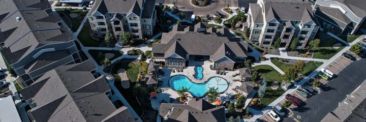
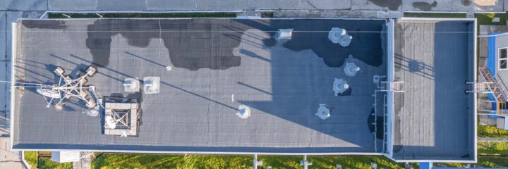
Baseline reality data refers to the accurate digital documentation of physical assets and environments prior to a significant event. This data can include high-resolution aerial imagery, orthomosaic maps, LiDAR scans, 3D models, digital twins, and other forms of reality capture.
These datasets provide a detailed snapshot of infrastructure, facilities, and surrounding environments under normal operating conditions. They serve as a permanent record that can be referenced after a storm to identify changes, quantify damage, and support recovery decisions.
For many organizations, baseline data may include electrical substations, transmission corridors, ports, bridges, roadways, levees, industrial facilities, water treatment plants, and other critical infrastructure assets. Capturing these assets before hurricane season creates a comprehensive digital inventory that becomes invaluable during recovery.
The Problem with Waiting Until After the Storm
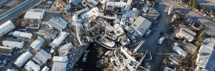
Many organizations begin collecting data only after damage has occurred. While post-disaster aerial surveys are extremely valuable, they tell only part of the story.
Without a pre-event record, recovery teams can spend significant time determining what changed, how severe the damage is, or whether the damage is actually from the disaster. This can slow down assessments, delay insurance claims, and make it more difficult to secure disaster assistance funding.
Aerial surveys conducted after a storm can reveal flooded roadways, damaged structures, and debris fields. However, when those same surveys are compared against baseline data collected before the storm, recovery teams gain actionable insights. They can quickly identify affected areas, measure changes, prioritize repairs, and make more informed decisions, resulting in a faster and more efficient recovery process.
How Aerial Surveys Improve Disaster Recovery Planning
One of the greatest advantages of pre-storm aerial surveys is the ability to accelerate damage assessments.
When recovery teams have access to current and historical datasets, they can compare conditions side by side and identify impacted assets immediately. Instead of spending days or weeks establishing what was there before the storm, they can focus on determining what needs attention right away.
This capability is particularly important for large infrastructure owners managing thousands of assets across wide geographic areas. Utilities can quickly assess transmission corridors. Ports can evaluate operational impacts. Municipalities can identify damaged roads, drainage systems, and public facilities.
Aerial surveys also strengthen documentation for insurance claims and disaster assistance programs. Detailed records of pre-storm conditions help demonstrate the extent of storm-related damage and reduce disputes regarding pre-existing conditions. This can help organizations navigate claims more efficiently and improve the recovery process.
In addition, baseline data supports better resource allocation. When decision-makers have accurate information about affected assets, they can prioritize repairs, deploy crews more effectively, and focus recovery efforts where they will have the greatest impact.

Why Drones Have Become Essential for Hurricane Preparedness
Traditional asset documentation methods often rely on ground inspections, photographs, and paper records. These approaches can be time-consuming, incomplete, and difficult to scale across large facilities or infrastructure networks.
Drone technology changes how organizations approach disaster preparedness.
Modern drone-based reality data capture allows organizations to rapidly collect high-resolution imagery and detailed spatial data across large areas. Facilities that may take days or weeks to document through traditional methods can often be surveyed much more efficiently using drones.
For infrastructure owners, this means creating comprehensive digital records before hurricane season begins. These records can be used not only for disaster recovery planning but also for routine inspections, asset management, engineering projects, and long-term resilience planning.
The ability to quickly capture accurate, repeatable datasets has made drone-based aerial surveys an increasingly important tool for organizations seeking to improve preparedness and reduce recovery timelines.


Don’t Wait Until a Storm Is in the Forecast
Every hurricane season brings uncertainty, but one thing remains predictable: organizations that are prepared recover more efficiently than those that are not.
Capturing baseline reality data before hurricane season provides a clear record of infrastructure conditions, supports faster damage assessments, strengthens insurance and funding documentation, and helps decision-makers allocate resources more effectively when disaster strikes.
Waiting until a storm is approaching often means competing for limited resources and operating under compressed timelines. The most effective disaster recovery plans begin months before severe weather develops.
If your organization relies on critical infrastructure, facilities, or assets that could be impacted by hurricanes, floods, or severe storms, now is the time to establish your baseline.
When recovery depends on knowing what changed, the most valuable data is often the data you captured before the storm.