Understanding Misconceptions About LiDAR Technology
LiDAR (Light Detection and Ranging) technology has revolutionized geospatial data collection. However, several misconceptions surround its capabilities and applications. Read on to clarify these misconceptions and gain a clearer understanding of when and how to use LiDAR effectively.
LiDAR vs. Photogrammetry: Understanding the Difference
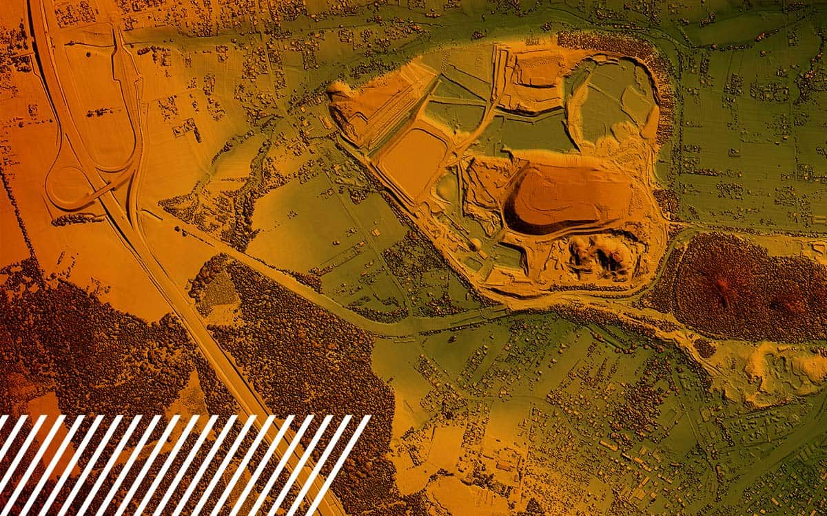
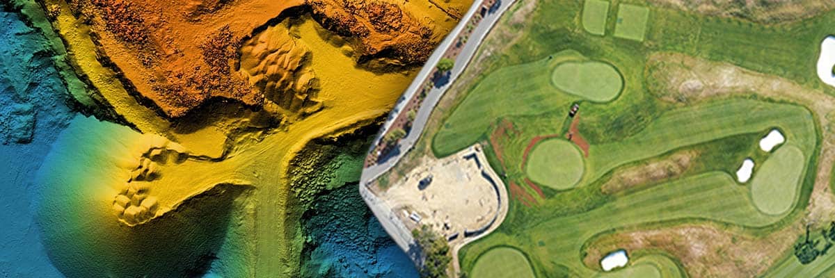
LiDAR and photogrammetry are often compared, yet each serves distinct purposes. LiDAR uses laser pulses to measure distances and generate precise 3D models. Photogrammetry, on the other hand, relies on photographic images to create models and maps.
While LiDAR is highly accurate, it isn’t inherently more accurate than photogrammetry. The choice between the two depends on the specific use case. For instance, LiDAR excels in capturing details through vegetation and in low-light conditions, whereas photogrammetry is ideal for areas with clear visibility and where high-resolution images are required.
Cost and Efficiency Considerations
LiDAR can be more expensive and time-consuming compared to photogrammetry, especially in scenarios with few trees. In these cases, the additional accuracy provided by LiDAR may not justify the cost, making photogrammetry a more practical choice.

Common Misidentifications: What LiDAR Is Not
One prevalent misconception is that LiDAR can penetrate the ground, water, or walls. In reality, LiDAR cannot perform these tasks, and it is essential to distinguish it from other technologies designed for such purposes.
LiDAR vs. Radar: Ground-Penetrating Radar (GPR) is specifically developed to detect objects, changes in material, voids, and cracks beneath the ground’s surface. It uses radio waves rather than light, allowing it to penetrate soil, rock, ice, and other surfaces. This makes GPR invaluable for applications such as archaeology, geology, and underground utility mapping, where it can reveal what lies beneath the surface without excavation.
LiDAR vs. Sonar: Water-penetrating technologies, such as sonar, use sound waves to map underwater terrains. Sonar technology is crucial for marine applications, including seabed mapping, underwater navigation, and detecting submerged objects. Unlike LiDAR, sonar can effectively penetrate water to provide detailed information about underwater environments.
Bathymetric focuses on the study and mapping of underwater topography, detailing the depths and shapes of seafloors, riverbeds, and lake bottoms. This field employs sonar technology to measure and map the underwater terrain. Sound waves travel through the water, bounce off the underwater features, and return to the sensor, allowing the calculation of depth and the creation of detailed maps. Bathymetric data is essential for marine navigation, environmental monitoring, dredging operations, and scientific research.
LiDAR, on the other hand, works by emitting laser pulses that can shoot thousands of times per second, primarily to measure distances through grass and foliage. It is highly effective at creating detailed 3D maps and models of surface features, even in areas with dense vegetation. However, these laser pulses are reflected off solid surfaces and cannot penetrate through them. This limitation means LiDAR cannot see through walls, water, or ground surfaces.
Detection Capabilities: Beyond LiDAR’s Reach
LiDAR’s primary function is to create high-resolution 3D maps of the earth’s surface by measuring distances with laser pulses. It provides detailed topographical data, identifies surface features, and maps areas with dense vegetation. However, when it comes to detecting gases, thermal variations, or specific material compositions, LiDAR is not the solution. The following sensors and cameras are better suited for these use cases.
Gases and Chemicals: LiDAR cannot detect gases such as methane or other chemical compositions. Detecting gases typically requires specialized sensors like Gas Detectors or Spectrometers that can identify and measure the concentration of specific gases in the atmosphere. These sensors are often used in environmental monitoring, industrial applications, and safety inspections to detect leaks, emissions, or the presence of hazardous substances.
Thermal Variations: LiDAR cannot measure temperature differences or thermal radiation. To capture thermal data, Thermal Imaging Cameras or Infrared Sensors are used. These devices detect infrared radiation emitted by objects and convert it into temperature readings. Thermal imaging is essential in various applications, including building inspections, electrical maintenance, and surveillance, where temperature anomalies need to be identified.
Multispectral and Hyperspectral Imaging: For applications requiring the identification of materials based on their spectral properties, Multispectral and Hyperspectral Cameras are used. These technologies capture data across multiple wavelengths of light, allowing for the detailed analysis of the composition and health of vegetation, soil, minerals, and other materials. They are widely used in agriculture, forestry, mineral exploration, and environmental monitoring.
Accuracy: The Strength of LiDAR
LiDAR is renowned for its high accuracy, achieving up to 10-millimeter precision for visible surfaces. This exceptional level of detail is one of the key strengths of LiDAR technology, making it indispensable for applications that require precise spatial data.
Comparison with GPS: While GPS technology is widely used for location tracking and navigation, its accuracy typically ranges up to 3 centimeters under optimal conditions. This level of precision is sufficient for general navigation, logistics, and some surveying tasks. However, for applications demanding finer detail and higher accuracy, LiDAR is the go-to solution. The ability to achieve 10-millimeter precision allows LiDAR to capture minute details of the terrain and structures, which GPS alone cannot provide.
High-Precision Mapping: In industries like construction, urban planning, and infrastructure development, the need for high-precision mapping is critical. LiDAR’s ability to create detailed 3D models ensures that construction plans are based on accurate topographical data, reducing errors and improving efficiency. For example, when planning the grading of a construction site or assessing the alignment of infrastructure projects such as roads and bridges, the precision offered by LiDAR ensures that every detail is accounted for, minimizing costly rework.
Forestry and Environmental Monitoring: LiDAR is particularly beneficial in areas with dense vegetation. Unlike photogrammetry, it can penetrate tree canopies and provide detailed analysis of forest canopies, biomass estimation, and the detection of small changes in vegetation over time. This level of detail helps in managing forest resources, monitoring habitat changes, and studying the impacts of climate change with a high degree of accuracy.
Archaeology and Heritage Conservation: In archaeology, LiDAR’s accuracy allows researchers to uncover and document ancient structures and landscapes that are not visible to the naked eye. The precise 3D models generated by LiDAR help archaeologists analyze site layouts, identify artifacts, and preserve heritage sites with minimal disturbance to the actual location.
Common Use Cases for LiDAR
There are various industries and use cases where LiDAR could be the best solution.
Surveying and Mapping: The Primary Use of LiDAR
LiDAR is predominantly used for surveying and mapping, particularly in areas with dense foliage or when creating digital twins of facilities. It provides detailed and accurate 3D models essential for planning and analysis in various industries, including construction, forestry, and urban planning.
Telecom and Utility Lines: A Unique Application of LiDAR
LiDAR is invaluable for inspecting telecom and utility lines. It can detect the lines and measure sag, which photogrammetry cannot capture due to the fine and granular nature of the wires. This capability is essential for maintaining infrastructure and ensuring safety.
Real Estate Development
In real estate development, LiDAR is useful for detailed earthwork measurements and planning. For roof scans or general property overviews, photogrammetry often provides sufficient detail, making it a cost-effective alternative to LiDAR.
Disaster Response and Reconstruction
In scenarios like natural disasters, car accidents, or bridge collapses, LiDAR can create detailed reconstructions and identify areas missed by photogrammetry. This ability to capture fine details and under-objects makes LiDAR crucial for comprehensive disaster response and analysis.

When Not to Use LiDAR
LiDAR is not typically used for mapping large green spaces without specific features requiring high-detail mapping. For such applications, other remote sensing technologies may be more appropriate and cost-effective.
In areas with minimal tree cover or for general overviews, photogrammetry may suffice. For tasks such as creating 5-foot contour maps, the high accuracy of LiDAR may not be necessary. Photogrammetry can efficiently provide the required data at a lower cost and faster turnaround. Read more about contours and when accuracy matters.
Agriculture: Differentiating Plant Canopies
While LiDAR can differentiate levels of plant canopies, multispectral imaging is more commonly used in agriculture. Multispectral cameras capture images in different wavelengths, helping to distinguish various plant species and monitor crop health. This technology is particularly useful for precision farming and environmental research.
Do You Need LiDAR?
Understanding the capabilities and limitations of LiDAR is crucial for selecting the right tool for your project. While LiDAR offers unparalleled accuracy and detail in specific applications, it is not a one-size-fits-all solution. By dispelling these misconceptions, users can make informed decisions and leverage the strengths of LiDAR and complementary technologies to achieve their goals.
FlyGuys, offers premium LiDAR services that utilize laser pulses to create highly accurate 3D models and maps of surfaces, ideal for surveying, forestry, and urban planning. Our LiDAR technology can penetrate vegetation, providing detailed ground data even in densely forested areas, ensuring comprehensive and precise data capture for your projects.
Contact us today to schedule your LiDAR scan.