A conversation with FlyGuys’ renewables expert, Grace McAdory, on how drone data is transforming solar and wind energy projects.
We sat down with Grace McAdory, FlyGuys’ in-house renewables expert, to explore how reality data capture using drones is changing the way renewable energy projects are executed. From land assessment and construction to commissioning and long-term maintenance. With tools like LiDAR, RGB, and thermal, stakeholders can receive high-quality insights faster, safer, and more cost-effectively than ever before.
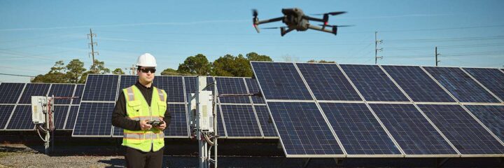
“Drones are such a crucial tool in every facet of a renewable energy project,” Grace says. “They give us accurate and actionable drone data in a fraction of the time compared to traditional methods and with a level of detail that’s incredibly hard to achieve manually.”
This means carriers can capture real-time property visuals without sacrificing their existing operational workflows. The result: improved data flow, reduced delays, and fewer manual bottlenecks.
Why Drone Reality Data Capture Matters for Renewable Energy
Drones play a crucial role in nearly every facet of a renewable energy project.
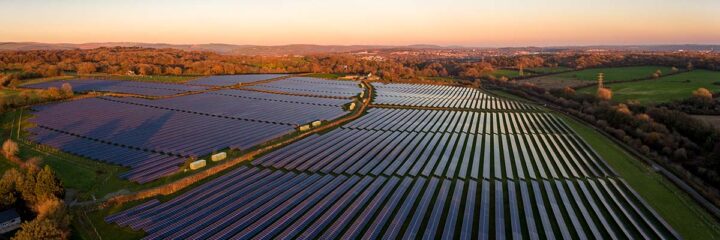
“Speed is one of the most obvious benefits,” Grace explains. A 4-5 megawatt solar site can take more than a day to inspect using traditional methods, making it untenable to conduct complete QC inspections on larger-scale sites. In the past, contractor quality assurance teams were capable of covering 1-3% of the area to completion.
Accuracy, data resolution, risk mitigation, and cost savings are also other benefits that come into play. Grace tells us, “Reality data capture has been transformative in this industry, shifting how projects are planned, built, inspected, and maintained.”
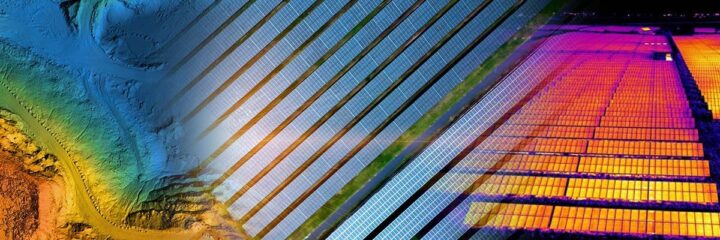
The Role of LiDAR, RGB, and Thermal in Renewable Energy Projects
Reality data capture through drone technology isn’t a one-size-fits-all solution; it’s a collection of tools and methods tailored to specific project phases. Grace broke down how each capture method plays a role:
1. LiDAR Drone Surveys – Understanding the Ground Before You Build
LiDAR drone surveys are often conducted during the pre-construction civil and design phases of a project, providing developers with an accurate topographic baseline dataset to work from. “LiDAR gives stakeholders a clear picture of the land they’re working with,” Grace says. “It helps with everything from drainage planning to understanding slope and elevation changes. These surveys help confirm the land is suitable and inform accurate earthwork estimates.”
2. RGB Drone Imagery – Tracking Progress from Ground Break to Commissioning
At its core, RGB drone imagery is a simple and effective capture method that produces high-resolution, color photos stitched into orthomosaic maps. It’s truly invaluable once construction begins. “Progress mapping is especially helpful for showing visualizations to stakeholders,” Grace explains. “You can track everything from panel installations to electrical component placements and compare it directly to your design plans.”
This helps project managers identify deviations early, confirm infrastructure is placed correctly, and keep everyone aligned across timelines and deliverables. The result is better project control and fewer change orders.
3. Thermal Drone Imaging – From Compliance to Ongoing Performance
Thermal drone imaging supports two distinct yet equally critical workflows: commissioning and operations & maintenance (O&M).
Commissioning Thermal Flights (Compliance Inspections)
Once a solar site is built, state regulations often require proof of IEC compliance. That means developers must capture a baseline dataset showing that the system performs to specification when it’s energized for the first time. “We use IR-compatible drones to collect that commissioning data,” Grace explains. “This helps clients prove their site is operating correctly and meets compliance requirements.”
O&M Thermal Flights (Ongoing Performance Monitoring)
After commissioning, many operators schedule recurring thermal drone inspections to identify potential issues before they escalate. “During O&M flights, we’re looking for anomalies like string outages, hot spots, cracked panels, shading, or damaged modules,” says Grace.

Accurate and Actionable Drone Data = Smarter Decisions
Across all three types of drone data capture — LiDAR, RGB, and thermal — the consistent value is clear: speed, safety, and accuracy. “It’s not just about flying a drone,” Grace notes. “It’s about delivering accurate and actionable drone data that helps our partners make better decisions at every phase of their project.”
This data enables our partners to identify inefficiencies early, reduce downtime, and stay ahead of regulatory requirements, all while cutting costs and minimizing time spent in the field.
Scalability and Standardization Across Projects
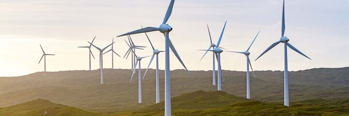
One of the biggest challenges in scaling renewable energy infrastructure is maintaining consistency across multiple sites and regions. FlyGuys addresses this by deploying a nationwide network of FAA-certified drone pilots who are trained to follow standardized capture protocols. “We’re built for scale,” says Grace. “Whether it’s a 10MW solar site in Texas or a 100-turbine wind farm in Iowa, our pilots are equipped to deliver consistent, high-quality data.”
That consistency matters when managing multi-site portfolios, reporting to investors, or coordinating with engineering teams.
What Should You Look for in a Drone Data Provider?
Grace emphasizes that working with drones isn’t just about flying, it’s about delivering reliable results. “You want more than just someone who can fly a drone. You need a reliable, long-term, scalable partner who delivers accurate and actionable drone data,” she says. “Every day when I show up to work, my mindset is focused on putting our partners’ needs first. Moving fast, staying responsive, and making sure they have exactly what they need to keep their renewable energy projects moving forward.”
Key things to look for include:
- Scalable operations that can grow with your portfolio
- Standardized processes across every capture method
- Fast turnaround time and responsive communication
- Deliverables that are clear, organized, and actionable
The Future: A Core Tool, Not a Luxury
Grace believes drone technology in renewable energy is no longer a “nice to have” but is now becoming fundamental. “It’s already a core part of how projects are being planned, built, and maintained,” she says. “And it’s only going to grow from here. We’re evolving alongside the technology, adapting to what our clients need, and scaling right along with them.”
The benefits are undeniable: faster turnaround, safer inspections, and high-quality data that fuels smarter clean energy development.
Final Takeaway
From LiDAR, RGB, and thermal, drones are proving indispensable to this industry. “At the end of the day,” Grace says, “drones help companies save time, reduce costs, and get better results. That’s why more teams are realizing drones aren’t just a cool tool, they’re a critical part of building the future of clean energy.”