
The commercial real estate industry has undergone a significant transformation with the integration of drone technology. What once required expensive helicopter surveys, manual inspections, and time-consuming ground assessments can now be accomplished efficiently and cost-effectively through advanced drone services. This technological revolution is particularly impactful in two critical areas: due diligence processes and insurance planning.
The Evolution of Property Assessment
Traditional property evaluation methods often left investors and insurers with incomplete pictures of their assets. Ground-level inspections could miss roof conditions, aerial perspectives were costly to obtain, and comprehensive site analysis required multiple specialists and extended timelines. Today’s drone services for real estate have eliminated these limitations, providing stakeholders with unprecedented access to detailed, accurate property data.
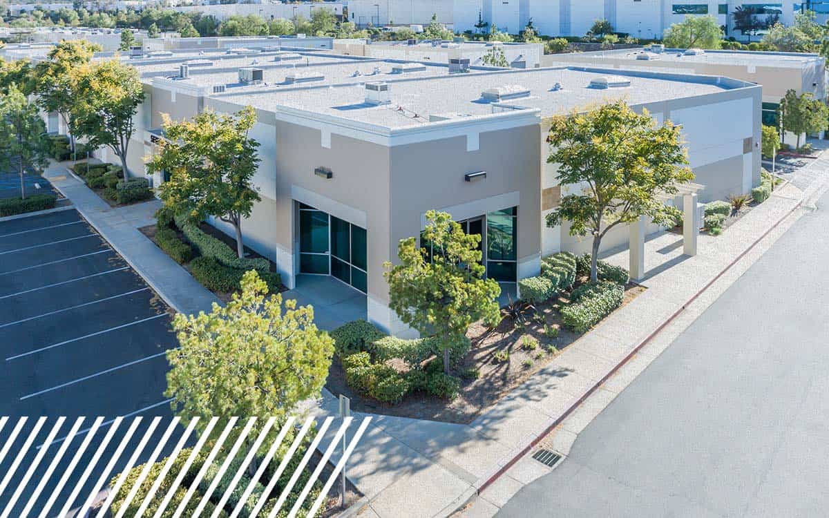
Real estate drone photos now offer investors and property managers crystal-clear views of every aspect of a property, from roofline integrity to parking lot conditions. This comprehensive visual documentation serves as the foundation for informed decision-making in both acquisition and ongoing management scenarios.

Enhancing Due Diligence Through Aerial Intelligence
Commercial real estate due diligence traditionally relied heavily on paperwork, historical records, and limited physical inspections. Drone technology has revolutionized this process by providing objective, comprehensive data that reveals both obvious and hidden property characteristics.
Structural Assessment and Documentation
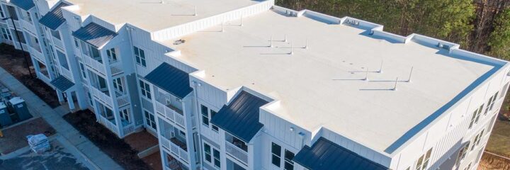
Modern drone services deliver high-resolution imagery that captures structural details invisible from ground level. Potential buyers can now identify roof damage, gutter problems, HVAC system conditions, and building envelope issues before finalizing transactions. This level of detail significantly reduces post-purchase surprises and enables more accurate property valuations.
The thermal imaging capabilities of advanced drones reveal energy inefficiencies, moisture intrusion, and insulation gaps that traditional inspections might miss. For commercial properties, these insights translate directly into operational cost projections and renovation budgets.
Site Analysis and Development Potential
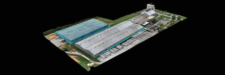
Beyond building assessment, drone mapping provides crucial insights into site utilization and development potential. Aerial surveys reveal drainage patterns, identify potential environmental concerns, and document existing infrastructure conditions. This comprehensive site analysis helps investors understand not just what they’re buying, but what they can do with it.
Topographical mapping through drone technology enables precise measurements of available land, accurate slope calculations, and detailed documentation of site features. This information proves invaluable for planning expansion, optimizing parking, and ensuring compliance with zoning requirements.
Transforming Insurance Risk Assessment
The insurance industry has embraced drone technology as a game-changer for risk assessment and policy underwriting. Using drones for insurance inspections provides carriers with objective, detailed property data, enabling more accurate risk modeling and fairer pricing.
Comprehensive Risk Documentation
Insurance inspectors using drone services can document property conditions with unprecedented thoroughness. High-resolution aerial photography captures roof conditions, identifies potential hazards, and provides baseline documentation for future claims comparison. This comprehensive approach benefits both insurers and property owners by establishing clear, objective records of property conditions.
Weather-related damage assessment becomes significantly more efficient with drone technology. After storms or other events, insurers can quickly deploy drones to assess damage across multiple properties, accelerating claims processing and reducing adjustment costs.
Predictive Risk Modeling
Advanced drone data collection enables sophisticated risk modeling that goes beyond traditional assessment methods. By combining aerial imagery with historical weather data, insurers can more accurately predict which properties are at elevated risk from specific perils. This enhanced modeling capability leads to more accurate pricing and helps property owners understand their risk profiles.
Fire risk assessment particularly benefits from drone technology. Aerial surveys can identify vegetation encroachment, assess defensible space around buildings, and document fire safety infrastructure. This detailed documentation supports both underwriting decisions and risk mitigation planning.

Advanced Mapping and Planning Applications
Modern drone services extend far beyond simple photography. Advanced mapping capabilities provide commercial real estate professionals with sophisticated planning tools that enhance both development and management decisions.
3D Modeling and Virtual Tours
Three-dimensional mapping capabilities create detailed virtual representations of properties that serve multiple purposes. Investors can conduct virtual site visits, architects can begin preliminary design work, and property managers can plan maintenance activities, all from detailed 3D models.
These virtual representations prove particularly valuable for marketing purposes. Potential tenants or buyers can explore properties remotely, reducing unnecessary site visits and focusing in-person meetings on serious prospects.
Infrastructure Planning and Compliance
Drone mapping services offer precise measurements and detailed documentation, supporting infrastructure planning and regulatory compliance. Utility companies can plan service routing, architects can design with accurate site data, and property managers can optimize traffic flow and parking arrangements.
Environmental compliance monitoring becomes more manageable with regular drone surveys. Properties can be monitored for erosion, vegetation changes, and potential environmental impacts, helping owners maintain compliance with regulatory requirements.
The Economic Impact of Drone Integration
The financial benefits of incorporating drone services into commercial real estate operations extend beyond immediate cost savings. Property owners and investors who leverage drone technology gain competitive advantages in acquisition, management, and disposition activities.
Cost-Effective Regular Monitoring
Traditional property inspections require significant time and labor investments. Drone services enable regular property monitoring at a fraction of traditional costs, allowing property managers to identify issues before they become expensive problems. This proactive approach reduces long-term maintenance costs and helps preserve property values.
Insurance premiums may also benefit from regular drone monitoring. Properties with documented maintenance histories and proactive risk management often qualify for preferred rates, creating ongoing savings that compound over time.
Enhanced Marketing and Leasing
High-quality aerial photography and virtual tours created through drone services enhance marketing materials and accelerate leasing activities. Properties can be showcased more effectively, reducing vacancy periods and supporting higher rental rates.
The professional presentation enabled by drone photography also supports higher property valuations. Well-documented properties with comprehensive visual records often command premium prices in competitive markets.

Emerging Opportunities in the Drone Services Industry
The growing demand for drone applications in commercial real estate has created numerous drone jobs and business opportunities. From specialized inspection services to comprehensive mapping operations, the industry continues to expand and evolve.
Professional Service Opportunities
Licensed drone operators with real estate industry knowledge are increasingly in demand. Property management companies, investment firms, and insurance carriers all require regular drone services, creating stable business opportunities for qualified operators.
Specialized services such as thermal imaging, 3D mapping, and environmental monitoring command premium rates and require advanced technical skills. These specialized applications provide drone service providers with opportunities to differentiate their offerings and establish sustainable competitive advantages.
Technology Integration and Innovation
The integration of artificial intelligence and machine learning with drone data collection is creating new possibilities for automated property analysis. These technological advances are creating opportunities for drone service providers who can offer sophisticated data analysis along with traditional photography and mapping services.
Cloud-based data management and sharing platforms are also expanding service possibilities. Drone operators can now offer comprehensive data management solutions that provide ongoing value to clients beyond initial data collection.

Best Practices for Implementation
Organizations looking to integrate drone services into their commercial real estate operations should consider several key factors to maximize benefits and ensure successful implementation.
Regulatory Compliance and Safety
Professional drone services must operate within Federal Aviation Administration guidelines and local regulations. Working with licensed, insured operators ensures compliance and protects property owners from liability concerns.
Privacy considerations also require attention, particularly for properties in densely populated areas. Professional drone operators understand privacy requirements and can structure operations to minimize concerns while gathering necessary data.
Data Management and Security
The valuable data collected through drone services requires secure storage and management. Organizations should establish clear protocols for data handling, sharing, and retention to maximize the value of their drone investments.
Integration with existing property management systems enables more effective use of drone data. Properties with comprehensive digital records can leverage drone data more effectively for decision-making and planning purposes.

Future Outlook and Opportunities
The commercial real estate industry’s adoption of drone technology continues to accelerate, driven by advancements in technology, decreasing costs, and growing recognition of the value these services provide. Property owners, investors, and insurance carriers who embrace these technologies gain significant competitive advantages.
As drone technology continues to advance, new applications and opportunities will emerge. Autonomous inspection capabilities, enhanced data analysis tools, and improved integration with other technologies will further expand the value proposition of drone services in commercial real estate.
The intersection of drone technology with commercial real estate represents a fundamental shift toward data-driven decision-making. Organizations that successfully integrate these capabilities into their operations will be better positioned to identify opportunities, manage risks, and optimize property performance in an increasingly competitive marketplace.
By leveraging the comprehensive capabilities of modern drone services, commercial real estate professionals can enhance their due diligence processes, improve insurance planning, and make more informed decisions that drive better outcomes for all stakeholders involved.