What is Multispectral Imaging?
Multispectral imaging is a powerful technology that simultaneously captures image data at specific wavelengths across the electromagnetic spectrum. Unlike traditional cameras that capture the entire visible light spectrum in a single image, multispectral cameras capture multiple images at different wavelengths. These images are then layered to create a single, comprehensive scene image. This method often includes several wavelengths outside the visible spectrum, providing a more detailed and insightful view of the captured scenes.
Differences Between Multispectral Imaging and Regular Photography
Regular photography captures images using three primary colors: red, green, and blue (RGB), reflecting how objects appear to the human eye under natural light. Multispectral imaging, however, captures specific wavelengths with each image, collecting multiple images at different wavelengths simultaneously. This enables the detection of features and materials invisible to the naked eye, allowing for more detailed analysis and interpretation.
Importance of Multispectral Imaging in Agriculture
Multispectral imaging is crucial in agriculture because it can capture details beyond human vision. Farmers can create index maps showing vegetation health or chlorophyll amounts in plants by layering specific wavelengths. These maps help farmers determine where to concentrate their efforts, catch diseases before they spread, and optimize resources.
For instance, disease prevention is critical for crops like sugar cane and corn, which grow tall and obscure the center of the field. By flying drones equipped with multispectral sensors, farmers can monitor the middle of the field, detect diseases early, and prevent them from spreading throughout the crops.
Additionally, multispectral imaging allows farmers to precisely determine watering, fertilizing, and treatment plans for specific sections of their fields, enhancing efficiency and resource management. This technology enables precision agriculture, leading to better crop yields and reduced resource use.
Types of Data Captured by Multispectral Cameras
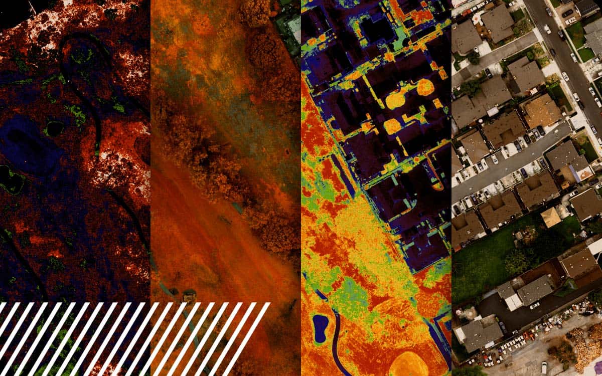
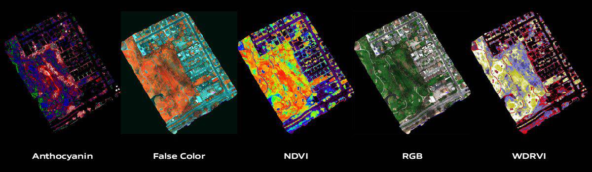
Multispectral cameras capture light reflectance at specific electromagnetic wavelengths. Each lens or filter is calibrated to detect particular light wavelengths that reflect off an object. This data is crucial for analyzing vegetation health, soil properties, water quality, and material composition. Specific indices, such as the Normalized Difference Vegetation Index (NDVI), can be derived from this data to provide actionable insights.
Drones and Multispectral Imaging
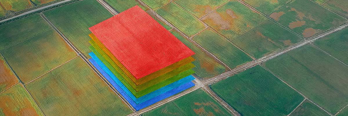
Drones equipped with multispectral sensors usually have 3-5 lenses, each calibrated to a different range of wavelengths. These lenses capture images simultaneously, so as the drone flies, it collects multiple images for each captured scene. These images are then layered to create different indices during processing. This approach is common in agriculture and environmental services and is also prevalent in autonomous mapping and planning.
Main Benefits of Multispectral Imaging
The primary benefits of multispectral imaging include:
- Enhanced Detection: Identifies features and conditions invisible to the naked eye.
- Precision: Provides detailed data for targeted interventions.
- Efficiency: Covers large areas quickly, saving time and resources.
Successful Use of Multispectral Imaging
Multispectral imaging has been successfully used in numerous applications, such as measuring plant health in agriculture, determining biodiversity, and assessing soil composition.
Here are some detailed examples of its impactful use across various sectors:
Vineyard Management
In vineyard management, drones equipped with multispectral cameras monitor vine health, assess water stress, and optimize harvesting schedules. This detailed monitoring leads to significant improvements in grape quality and yield. By analyzing the multispectral data, vineyard managers can identify areas of the vineyard that require more water or nutrients, detect early signs of disease, and determine the optimal time for harvest to ensure the best quality grapes.
Crop Disease Management
Early disease detection is vital in large-scale farming, especially for crops like sugar cane and corn. Multispectral imaging enables farmers to monitor the health of their crops by capturing data on plant reflectance at various wavelengths. This helps detect early signs of diseases that might be missed by the naked eye, especially in dense crop fields where it is challenging to inspect the center visually. By identifying and addressing issues early, farmers can prevent diseases from spreading, saving significant portions of their crops and ensuring better yields.
Biodiversity and Environmental Monitoring
Extensively used to monitor biodiversity and environmental changes, multispectral imaging helps map different plant species in a forest, tracking changes in vegetation over time and assessing the impact of environmental stressors such as drought or pollution. This technology is crucial for conservation efforts, allowing scientists to accurately monitor endangered species and their habitats.
Precision Agriculture
Multispectral provides detailed information on soil properties, crop conditions, and environmental factors, helping farmers make informed decisions about planting, fertilizing, and irrigating their fields. This targeted approach reduces waste, conserves resources, and improves crop productivity. For example, farmers can use multispectral data to create variable rate application maps for fertilizers and pesticides, ensuring that these inputs are used only where needed and in the correct amounts.
Soil Composition and Health Assessment
By capturing data on the reflectance properties of soil, multispectral technology helps identify soil types, detect nutrient deficiencies, and assess soil moisture levels. This information is vital for making informed decisions about soil management practices, such as when to irrigate or apply soil amendments.
Urban Planning and Infrastructure Inspection
Beyond agriculture and environmental monitoring, multispectral imaging is valuable in urban planning and infrastructure inspection. It helps assess the health of urban green spaces, detect heat islands, and monitor the condition of infrastructure such as roads and bridges. This application ensures that urban environments are managed sustainably and infrastructure is maintained effectively.
Archaeological Discoveries
Multispectral imaging has also been instrumental in archaeology. It helps detect buried structures and artifacts that are not visible on the surface. By analyzing different wavelengths, archaeologists can identify subtle differences in vegetation and soil that indicate the presence of ancient structures. This non-invasive method allows for the exploration and documentation of archaeological sites with minimal disturbance.
Overall, the successful use of multispectral imaging spans various fields, demonstrating its versatility and significant impact. This technology continues to evolve, offering even more precise and detailed data, driving innovation, and improving outcomes across multiple industries.

Calibrating Multispectral Cameras on Drones
Calibrating multispectral cameras involves setting the sensors to capture accurate data across all spectral bands. Before every flight, the camera must be calibrated using a panel with known reflectance. By taking a few images of this panel, the camera settings are adjusted for accurate data capture. This process ensures consistent data quality across different missions, unlike RGB cameras that do not require such calibration.

Challenges in Capturing and Processing Multispectral Data
Capturing and processing multispectral data with drones presents several challenges:
- Weather Conditions: Cloud cover and lighting variations can affect data quality. Using light sensors to track the sun and capturing data on days with minimal clouds and around noon helps mitigate these issues.
- Data Volume: Large datasets require significant storage and processing power. Efficient data management systems and cloud computing can address this issue.
- Sensor Calibration: Ensuring sensors remain calibrated over time requires regular checks and maintenance routines.
- Interpretation Complexity: Multispectral data can be complex to interpret, requiring specialized software and training.
Industries Using Multispectral Imaging Besides Agriculture
Besides agriculture, multispectral imaging is used in:
- Environmental Monitoring: Tracking ecosystem health, deforestation, and water quality.
- Mining and Geology: Identifying mineral compositions and analyzing soil properties.
- Infrastructure Inspection: Detecting structural issues in buildings, bridges, and other infrastructure.
- Archaeology: Revealing hidden structures and artifacts below the surface.
Role of Software in Multispectral Data Interpretation
Software is crucial in processing, analyzing, and visualizing multispectral data. It helps in:
- Data Calibration: Correcting sensor data for accurate analysis.
- Image Processing: Creating composite images and extracting relevant features.
- Data Analysis: Applying algorithms to derive indices like NDVI for vegetation health.
- Visualization: Generating maps and reports for straightforward interpretation.
Recommended tools include Pix4D, Agisoft Metashape, and ENVI, which offer comprehensive solutions for processing and analyzing multispectral data.
Learning to Use Multispectral Imaging Technology
Learning to use multispectral imaging technology involves understanding the hardware (sensors and drones) and software (data processing and analysis). While it can be complex, many resources and training programs are available to help users get up to speed. With hands-on practice and proper training, users can become proficient in capturing and interpreting multispectral data. The difficulty primarily lies in the analysis phase, which requires understanding calibration, environmental effects, and avoiding errors.
Advancements in Multispectral Sensor Technology
Recent advancements in multispectral sensor technology include:
- Higher Resolution Sensors: Improved image quality and more detailed data capture.
- Enhanced Sensitivity: Better detection of subtle differences in spectral signatures.
- Compact, Lightweight Designs: Easier integration with drones and increased flight efficiency.
- Automated Calibration: Simplifies the process of ensuring data accuracy.
These advancements have made multispectral imaging more accessible, reliable, and effective across various applications.
Future of Multispectral Imaging
The future of multispectral imaging looks promising with continued advancements in sensor technology, data processing algorithms, and integration with other remote sensing technologies. We can expect:
- Improved Accuracy and Resolution: Enabling even more detailed analyses.
- Wider Adoption: Across diverse industries as costs decrease and technology becomes more user-friendly.
- Integration with AI and Machine Learning: For automated data interpretation and real-time decision-making.
- Enhanced Applications: Including smart farming, precision medicine, and advanced environmental monitoring.
Overall, multispectral imaging will continue to provide valuable insights and drive innovation across multiple fields, significantly improve efficiency, cost savings, and informed decision-making.