
Preserving the Past Through Digital Twins
At the intersection of culture and connectivity, LFT Fiber partnered with FlyGuys to transform a historic site into a living digital asset. As part of LFT’s “Powered by Connectivity Summit,” the project set out to demonstrate how advanced drone data capture and digital twin technology could preserve Vermilionville’s heritage, ensuring its stories endure in both physical and digital form.
Executive Summary
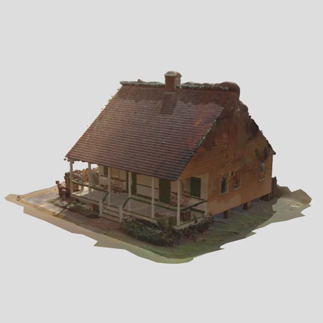
LFT Fiber collaborated with FlyGuys to create a high-fidelity digital twin of Vermilionville, a historical village in Lafayette, LA, using ground-based LiDAR SLAM scanning and immersive reality capture powered by NavVis technology. By capturing, structuring, and reconstructing spatial data into an immersive digital environment, FlyGuys delivered more than visuals. They created a scalable framework for historic preservation through data.
The Challenge
LFT’s vision was ambitious: bridge the past and future by turning a historic site into an interactive digital experience. However, several technical and operational barriers stood in the way:
- Capturing accurate spatial data across complex, irregular historic structures
- Transforming raw aerial imagery into a cohesive, navigable 3D model
- Operating within restricted airspace near an airport
- Coordinating multi-stakeholder logistics at an active heritage site
Previous attempts to conceptualize similar projects revealed a key limitation: creating digital twins requires not only capture tools but also a structured data pipeline and processing expertise.


The Solution
FlyGuys approached the project as a full digital twin workflow, leveraging NavVis mobile mapping technology to create an immersive, spatially accurate digital replica of Vermilionville.
Reality Capture Layer
Using the NavVis system, FlyGuys conducted high-precision ground-based scanning throughout the site:
- Captured LiDAR point cloud data and immersive imagery simultaneously
- Collected spatial data while walking naturally through structures and pathways
- Recorded highly detailed environmental geometry, textures, and dimensions
- Included 360 imagery for Google Street View experience
- Ensured seamless coverage across interiors, exteriors, and transitional spaces
Unlike traditional static-scanning workflows, NavVis SLAM scanning enables efficient mobility while maintaining survey-grade spatial awareness and visual continuity.
Data Processing Layer
- Consolidated millions of points into a cohesive point cloud
- Generated textured 3D meshes using photogrammetry software
- Applied geospatial alignment to ensure real-world accuracy
Digital Twin Output
- Delivered an immersive, spatially accurate 3D model of Vermilionville
- Enabled virtual exploration and long-term archival of site conditions
- Produced an experiential environment with photo and spatial realism.
By acting as a data conduit, FlyGuys ensured consistency from capture through output, connecting LFT with a certified pilot, standardized workflows, and reliable deliverables.


Implementation Process
The project evolved from inspiration to execution through close collaboration:
- Concept to Reality: Inspired by digital twin examples like reconstructed ghost towns, LFT and FlyGuys aligned on creating a real-world proof of concept
- Site Integration: Vermilionville stakeholders were engaged to align on preservation goals and access
- Capture Execution:
- Reviewed the location’s unique capture qualities
- Produced an optimal walking path for consolidated capture
- Iterative Processing & Refinement:
- Initial models were reviewed and evaluated
- FlyGuys returned 3–4 weeks later to capture additional datasets for improved model density
- Refined mesh quality, texture resolution, and coverage gaps
This iterative loop—capture, process, refine—was critical to achieving a usable, high-quality digital twin rather than a one-time visualization.
OUTCOME
Results & ROI
Metric Callouts
- 3–4 weeks of additional capture and refinement to enhance model accuracy
- High-overlap image datasets enabling detailed 3D reconstruction
Impact Highlights
- Transformed a historic site into a persistent digital asset https://hope.lftfiber.com/
- Enabled virtual access to culturally significant environments
- Established a repeatable digital twin pipeline for future preservation projects
- Demonstrated how drone data can move beyond imagery into structured, usable datasets
Perhaps most importantly, the project reframed preservation: not as static documentation but as interactive, data-rich storytelling.
Testimonials
What Our Client Says
KEY TAKEAWAYS
- Digital twins require more than capture. They require a pipeline. Structured data processing is what transforms imagery into usable assets
- Iteration drives quality. Returning for additional data collection significantly improved the final model
- Historic preservation is evolving. Digital environments can extend access, education, and longevity of cultural sites
- Scalability is within reach. With the right workflow, this model can be replicated across other heritage locations
Get A Quote
Take Your Project To New Heights
No matter where your project is located, FlyGuys connects you with certified, FAA-compliant drone pilots ready to capture the data you need—quickly, safely, and reliably.
Request a quote today and let our team match you with the right drone solution for your project.
Please note that we are currently unable to assist in the search for missing pets. This limitation is due to the specific challenges and regulations associated with using drones for such purposes.