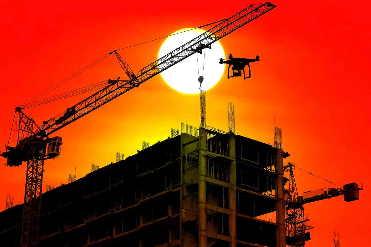
Drone Services in Construction
Better Site Visibility. Smarter Project Decisions.
Construction projects demand accuracy, speed, and coordination. FlyGuys provides nationwide drone services that help construction teams capture real-time site data, track progress, and reduce risk, without slowing down operations.
By delivering consistent aerial data throughout the project lifecycle, drones support more informed decisions that help teams stay on schedule, control costs, and improve overall site safety.
Site Intelligence That Drives Progress
Drone data allows construction teams to document more area in less time, monitor sites remotely, and share updates with stakeholders instantly. With centralized access to accurate, up-to-date visuals and measurements, teams can improve communication, minimize rework, and keep projects moving forward.
What Drone Data Delivers on the Jobsite
High-Resolution Visual Documentation
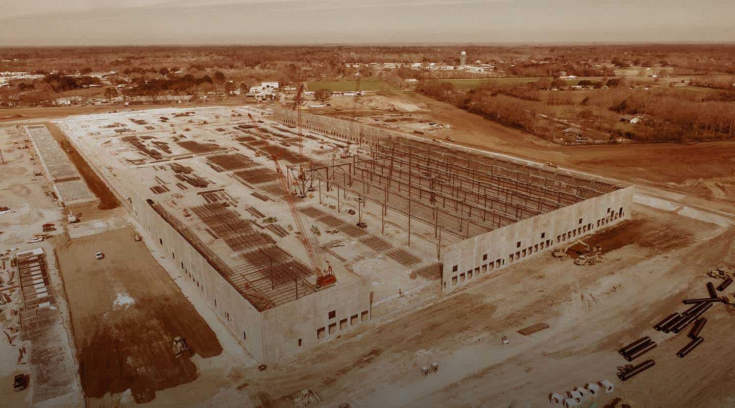
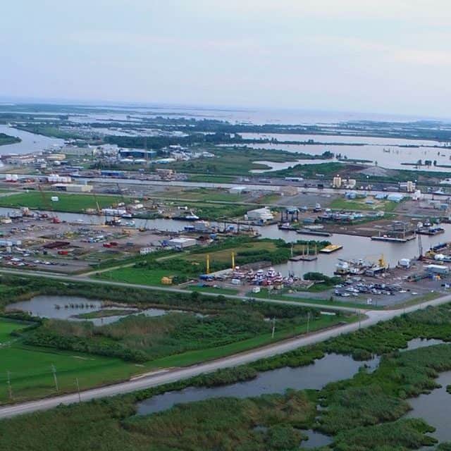
Construction projects depend on clear, accurate visibility of jobsite conditions at every phase. FlyGuys provides high-resolution aerial imagery and video that create a reliable, time-stamped visual record of your site, from pre-construction through closeout.
Drone capture allows teams to document work from multiple angles, verify completed tasks, and maintain a defensible record of site conditions, installations, and changes as they occur. This level of visibility supports better decision-making, higher quality control, and improved project oversight without disrupting active operations or putting personnel at risk.
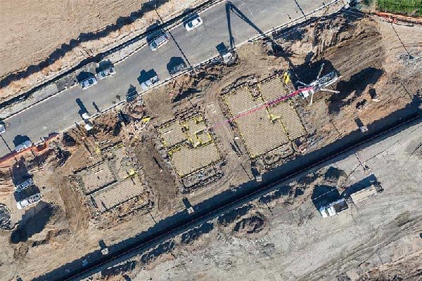
Progress Monitoring at Scale
Large construction sites involve multiple crews, assets, and timelines working simultaneously. Drone imagery allows project managers to quickly assess progress across the entire site and identify areas where work may be delayed, out of sequence, or incomplete.
By providing a clear aerial view of ongoing activity, aerial imagery helps teams understand what’s happening on-site, validate productivity, and address potential issues early before they impact schedules or budgets. Consistent progress capture improves accountability and helps keep projects moving forward efficiently.
Clear Stakeholder Updates
Keeping owners, investors, and stakeholders informed is critical to project success. FlyGuys’ drone services make it easy to share up-to-date aerial visuals that clearly communicate progress without requiring site visits.
High-resolution images and video provide stakeholders with a clear understanding of how the project is advancing, helping align expectations, reduce misunderstandings, and build confidence. Visual updates offer a simple, effective way to document progress and maintain transparency throughout the construction lifecycle.
Time & Cost Efficiency
Drone services allow construction teams to capture more information in less time compared to traditional methods. Aerial data collection reduces the need for manual site walks, repetitive inspections, and additional labor, helping teams work more efficiently.
By improving visibility, minimizing rework, and supporting faster decision-making, drones help control costs and keep projects on schedule. Construction companies, developers, and investors benefit from reduced labor expenses, fewer delays, and improved overall project efficiency.
Centralized Team Access
Construction projects involve coordination between designers, engineers, inspectors, superintendents, and field crews. Drone imagery provides a shared visual reference that teams can access to review site conditions, verify installations, and support planning.
Centralized access to aerial visuals improves communication across teams, reduces misalignment, and provides a reliable record for future reference. Whether reviewing progress or documenting completed work, drone data helps teams stay aligned and productive throughout the project.
Improved Jobsite Safety
Construction sites present significant safety risks, especially when inspections require access to elevated, confined, or hazardous areas. Drone inspections reduce the need for personnel to enter dangerous conditions, helping lower the risk of injury.
Aerial imaging allows teams to inspect roofs, structures, trenches, and active work zones safely and efficiently. By eliminating unnecessary exposure and enabling remote inspections—even after weather events—drones help maintain safety standards while keeping projects on track.
The Site Data Construction Teams Rely On
FlyGuys delivers high-resolution aerial imagery that provides a consistent, real-time view of your jobsite, supporting documentation, monitoring, and verification throughout every phase of construction.
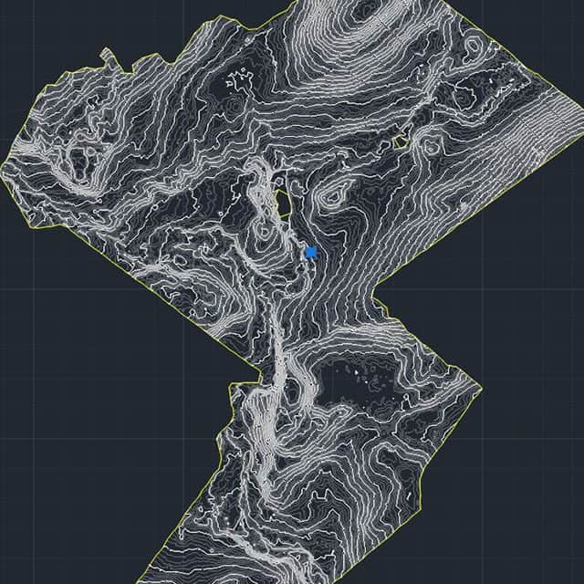
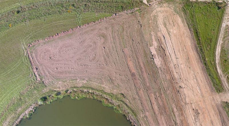
Topographic Mapping
Accurate topographic mapping is critical for construction planning, site development, and earthwork management. FlyGuys uses drone technology to capture high-resolution elevation and surface data across large construction sites faster and more efficiently than traditional survey methods.
Drone-based topographic mapping provides detailed insight into terrain, grading, and site conditions, supporting activities such as pre-construction planning, cut/fill analysis, and progress verification. By collecting reality aerial data, construction teams gain a clearer understanding of existing conditions, helping reduce rework, control costs, and keep projects on schedule.
FlyGuys delivers construction-ready topographic maps that integrate seamlessly into CAD and GIS workflows, providing reliable site intelligence you can use throughout the project lifecycle.
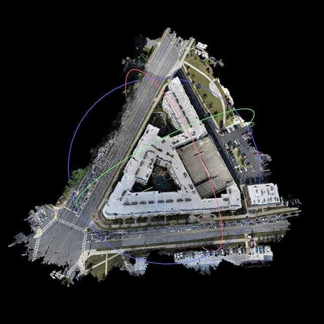
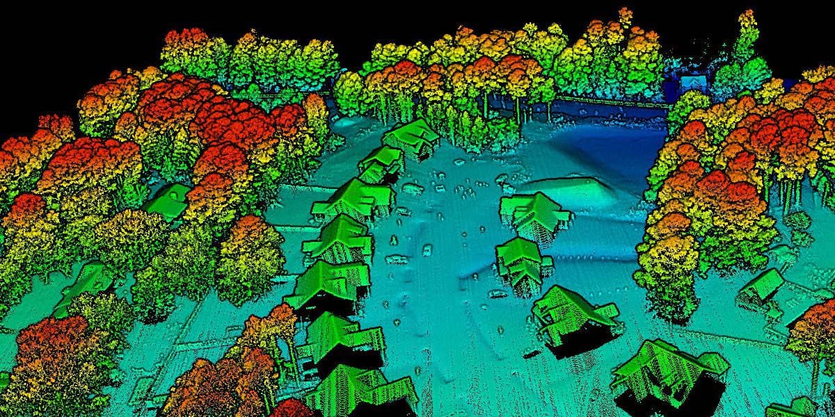
3D Modeling
High-resolution aerial imagery can be used to create accurate 3D models of construction sites and structures. These models give project teams a clear view of existing conditions, helping identify potential conflicts, constructability issues, and design deviations early, before they lead to rework or material waste.
3D models also support progress verification by comparing as-built conditions to design plans, keeping teams aligned with the original scope. For owners and stakeholders, 3D visualizations provide an easy way to understand project progress and see how the finished structure is coming together.
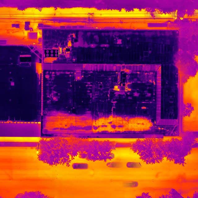
Thermal and Multispectral Imaging
Thermal and multispectral drone imaging help construction teams identify issues that aren’t visible to the naked eye before they lead to delays, rework, or material waste.
These imaging services are commonly used on construction sites to locate heat loss, moisture intrusion, insulation gaps, and material inconsistencies. When combined with aerial mapping, thermal data provides added context for site conditions, helping teams verify installation quality, assess building envelopes, and support more efficient use of materials throughout the project lifecycle.
Inspections
Drone inspections provide a safer, faster way to assess construction sites without disrupting work or putting personnel at risk. High-resolution aerial imagery allows teams to inspect roofs, structures, facades, and hard-to-reach areas with accuracy and consistency.
Captured visuals are quickly delivered to project managers, engineers, and inspectors supporting immediate decision-making, documentation, and future reference. Drone inspections help reduce downtime, improve safety, and maintain a clear visual record of construction conditions over time.
Aerial Photography for Construction Marketing
Professional aerial photography and video showcase construction projects from a compelling, high-impact perspective. Drone visuals provide polished assets for marketing, proposals, and project portfolios, helping communicate scale, progress, and quality.
Easily share digital imagery across websites, presentations, and promotional platforms to highlight completed work and attract future clients.
Dredging Projects
In addition to construction drone services, FlyGuys supports infrastructure restoration projects in collaboration with local governments, state agencies, and private contractors. Our aerial data capture helps document conditions for levees, waterways, and other critical infrastructure, providing timely, accurate insight for remediation planning, environmental impact studies, and restoration efforts.
By delivering reliable data faster than traditional methods, FlyGuys helps teams move projects forward efficiently while supporting informed decision-making across restoration and development initiatives.
From groundbreaking to ribbon cutting
FlyGuys is your construction drone services provider
Pre-Plan
Find the ideal location for your construction project before design starts to prevent future land issues.
Keep Clients in the Loop
Keep clients happy throughout the process of the project by keeping them in the loop with real-time progress. Let clients see how their investment is coming along.
Share Data in Real Time
Drone services allow you to share live data collection with internal teams and interested parties to make better business decisions and address problems on the spot.
Safety
Increase safety on site for inspectors and employees. Reduce work-related injuries and decrease the cost of liabilities.
Progress Monitoring
View the progress of your project from anywhere at any time with construction site aerial imagery. Address problems immediately, ensure progress is following schedule, make decisions to improve procedures and monitor equipment and employees.
Accountability
Assess productivity of crew and keep track of lost and damaged equipment.
Communication
Streamline communication between investors, staff, engineers, designers, architects and management. Access data from a centralized database.
Invoicing
Improve invoicing accuracy by storing all data from start to finish and spending less time calculating costs at the end of a project.
Bids
Our highly detailed construction site aerial photography and data enable the delivery of a more precise and accurate bid package with fewer exclusions due to unknown variables.
Make Your Company More Competitive
Drone data collection is more accurate and detailed than manual collection. Set your company apart with the newest technology in the industry and help keep investors’ costs down.
Sectors of Construction we work with
- Residential
- Non-residential
- Infrastructure
- Engineering
- Industrial
- Commercial
Other Uses for Drones in Construction
Even more ways drones can help on your construction site:
- Equipment tracking
- Volumetrics
- Security Surveillance
Drone Construction Progress Monitoring
From groundbreaking to opening day, monitoring the progress of your construction project is critical to keeping investors informed, spotting potential problems, and staying on time and within budget. For larger undertakings, such as sprawling infrastructure projects or multi-building complexes, drone construction progress monitoring is an efficient and cost-effective way to stay on top of your next project.
Using Drones for Construction Project Monitoring
Historically, most aerial views of construction sites were obtained through helicopter photography. This method has proven to be time-consuming, expensive, and inefficient, and as a result, the use of unmanned aerial vehicles (UAVs), or drones, is rapidly gaining popularity as a highly-effective alternative method of construction monitoring.
Drones controlled by an experienced pilot can be flown high above the job site, sending real-time information to the engineers and project managers on the ground. At the same time, UAVs collect high-resolution images that can then be used by licensed surveyors and mappers to create 3D models. Crucially, drones can fly close to the construction area, providing close-up shots of multiple areas around the jobsite.
Why Architects and Engineers Use Drone Data
Advancing Site Safety
Drone services reduce the need for personnel to access hazardous or hard-to-reach areas. Inspections, assessments, and documentation can be completed safely from above—helping protect workers while maintaining project momentum.
Minimizing Costs
By minimizing manual site visits, reducing rework, and improving visibility into site conditions, drone data helps control costs without sacrificing accuracy. Faster data collection supports more efficient planning and execution.
Increasing Productivity
For projects on a tight schedule, any delay can be disastrous. Drones save time by rapidly scanning large areas to collect data for safety and maintenance without shutting down the entire site.
Build a future with FlyGuys
FlyGuys has a nationwide network of FAA-certified, insured pilots ready to gather aerial data for your next project. From blueprints to groundbreaking to ribbon-cutting, FlyGuys can fly with you through each stage of your project to bring you high-quality, accurate details to ensure smooth workflow and successful outcomes.
Get A Quote
Take Your Project To New Heights
No matter where your project is located, FlyGuys connects you with certified, FAA-compliant drone pilots ready to capture the data you need—quickly, safely, and reliably.
Request a quote today and let our team match you with the right drone solution for your project.
Please note that we are currently unable to assist in the search for missing pets. This limitation is due to the specific challenges and regulations associated with using drones for such purposes.